Date: October 1, 2024
Location/Route Map: Kananaskis Valley
Elevation: 2310 m
Elevation Gain: 1200 m
Distance: 18.5 km
Rating: Class 2/3 - Easy/Moderate
Notes: A simple alternative to the classic traverse from Heart Mountain.
GPS Track: Download
The 2024 summer was pretty much a complete throw away for me. Other than a couple short backcountry trips in July and a little "birthday summit" in August, I spent the entire scrambling season going completely stir crazy, reading other people's trip reports as they beat me to exploring various routes I've drawn out on my map. All the while I'm stuck sitting on my butt, waiting for what feels like an eternity for my injured ankle to heal. Jewell Peak has interested me for a while now - being my final remaining summit surrounding Barrier Lake - but its classic route is said to involve a sketchy downclimb (or rappel) and traverses from Heart Mountain and Grant MacEwan Peak - both of which I'd already climbed in a horseshoe loop back in 2016. I therefore found myself searching for a different route up this mountain and wondered if I could access it from the Kananaskis side, making use of the Stoney and Jewell Pass Trails, before following the drainage that wraps around Jewell Peak to the NE, and finally ascending the NW slopes. I didn't think this minor summit received very much attention, and thought that the only people interested in climbing it would be the ones who tag it on while bagging Heart and MacEwan, so I have to admit I was quite surprised when I read Vern's report, following the route I'd drawn out to a tee! Looks like I didn't have to wonder about it anymore!

Having enjoyed our little larch hunting trip last September, my mom was eager to see the pretty fall colours again this year, and I just couldn't help myself from tagging along. My unscratchable "mountain itch" was only growing stronger, and after going to physio for the past month I decided it was time to test out my ankle again and see how it held up on an "easy" mountain.
As we turned off from the Trans Canada and onto Hwy 40, we were met with the depressing sight of thick grey cloud engulfing all but the "frontest" of the front range peaks. We were originally hoping to drive deeper into Kananaskis to "ooh" and "ahh" over the celebrites of the Rockies at this time of year (ie. larches), but couldn't bring ourselves to leave the small patch of sunlight at the gateway to the Rockies, and pulled off at a surprisingly empty Barrier Lake parking lot instead.

Jewell Peak was genuinely the only mountain in the vicinity that I hadn't climbed yet, so that made my decision easy as we bundled up for a very windy walk around the eastern shore of Barrier Lake. As we rounded the lake to the sheltered cutline along its north side, our walk became significantly more pleasant and we soon found ourselves shedding layers and pausing every few minutes to admire all the beautiful shades of red, orange, and yellow leaves vibrantly popping out from their evergreen neighbours. While I can almost guarantee the Highwood Pass parking lots were bursting at the seams even dispite the dull, whiteout conditions, we had this autumn paradise completely to ourselves, just because the trees surrounding us weren't called "larches". Gotta love the social media effect. LOL.


After a leisurely 4 km stroll around the lake, we arrived at the Jewell Pass Trail junction and started up the narrow path along the creek, kept on our toes by the odd mountain biker that came ripping down the single track! The weather was slowly starting to deteriorate, with dark clouds threatening just over Jewell Peak to the west, but I was hopeful that the storm wouldn't make any further advancements and we soon arrived at my chosen drainage (easily identified by a bridge crossing over a waterfall), which I prompty started up while my parents continued their hike to Jewell Pass.


As I made my way up the bushy drainage I quickly realized that I was in for a little bit more than I bargained for on this particular day. The smooth boulders underfoot were quickly becoming slick as rain drops began to fall, and I was immediately regretting my choice of wearing my old, worn out, grip-less boots for this "easy" scramble...The whole point of climbing this mountain was to test out my ankle - not break it!! Oh well! I'd already come this far so there was nothing to do but take it slow, choose each step carefully and not do anything overly stupid!

I tried to avoid the slippery, ankle-breaking creekbed as much as I could, and bushwhacked on one side or the other - frequently crossing back and forth as I hunted down the path of least resistance. Faint animal trails were always a welcome sight, but they never lasted as long as I would have liked and I still had to deal with my fair share of deadfall obstacle courses and slick boulder hopping. I had a few close calls, slipping on a wet rock or tripping over a tree branch, and each time I'd pause, wonder if my ankle was going to hate me for what I was doing, and ask myself if this mountain was really worth it. I guess it was, because each time I continued onward. 😂


After a longer than expected "streamwhack" I finally arrived at the base of Jewell Peak's NW scree ascent slopes. I couldn't believe how "close" I was to the ridge above and genuinely believed I would reach it in another 15-20 minutes...NOPE! The valley fell away below me as I quickly gained elevation on solid rock ribs, but the twin summits rising above just never seemed to get any closer! What I could've sworn was only 100 m from the drainage ended up being over three times that far, and my cramping thighs made sure to remind me how out of shape being an injured couch potato all summer makes you as I inched my way towards the deceptively distant summit ridge.


As I neared the ridge, I considered sidehilling over to the west summit first, saving on some elevation gains and losses, but knew that I was already testing my luck with my fragile ankle and decided to stick to more "ankle-friendly" terrain - ascending directly to the east summit before following the ridge to the west.

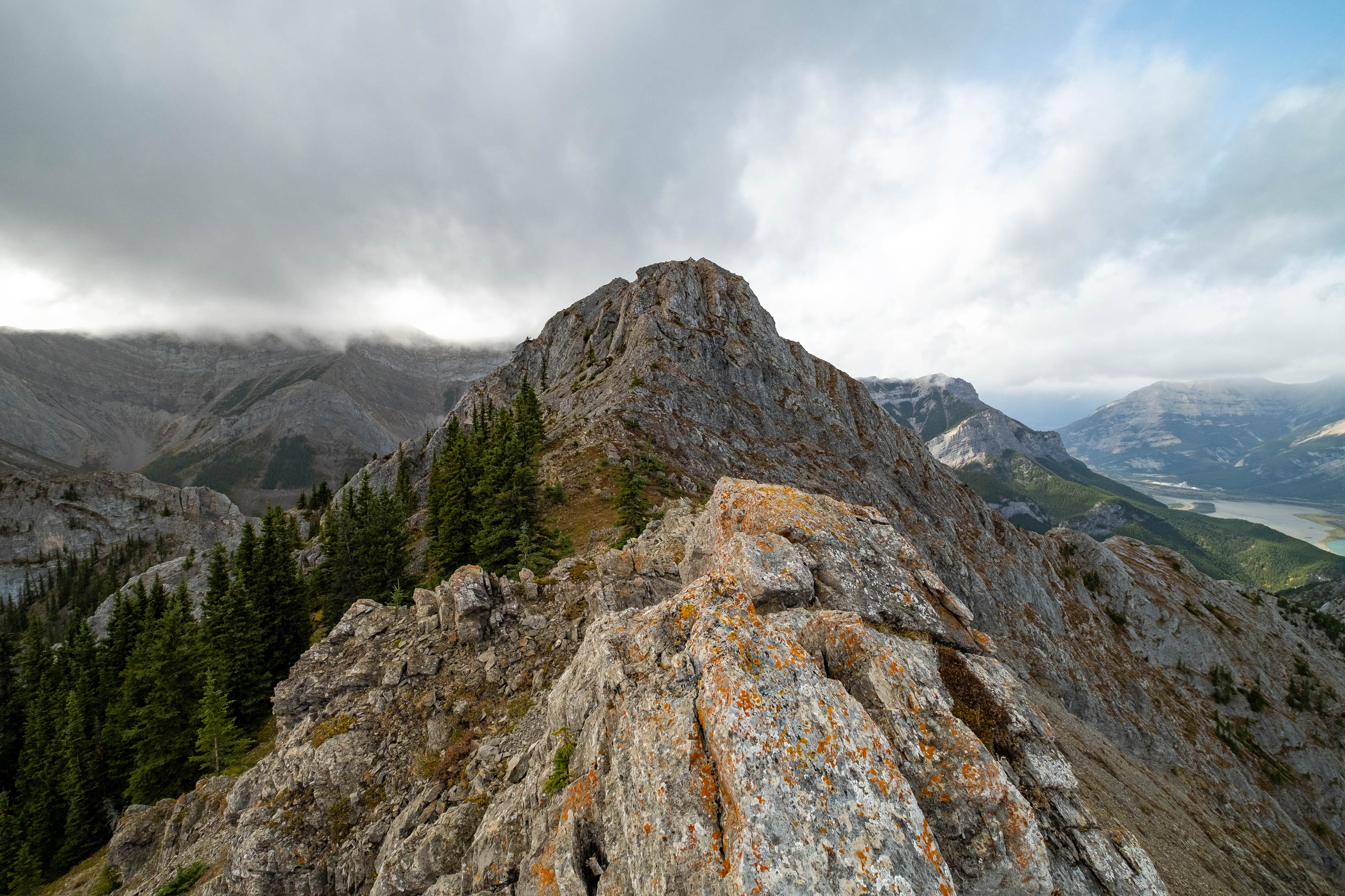
Views from the east (true) summit of Jewell Peak were largely obstructed by low cloud, but I was thankful that my peak remained one of the few holding out on the edge of the whiteout and enjoyed a unique view down to Barrier Lake before the icy autumn wind chased me down the ridge towards the slightly lower, but more impressive-looking west summit.

I knew an easier route existed by ascending the summit block around its left (south) side, but I was itching to stick my nose into some challenging terrain again and tackled the ridge head on. After ascending two short steps of difficult scrambling (at least they felt that way as I clung to the cold, damp rock with my nearly numb, exposed finger tips!), the terrain eased off and I easily made the final few steps to a waiting summit cairn.


Keeping my camera lens clean was a losing battle as the relentless wind "sprayed" me with rain (and even briefly snow!), and after spending way too much time wiping water droplets off my lens and not much time actually taking pictures, I accepted defeat and descended the easier, scree bypass before retracing my steps back up to the east summit.


For my descent I continued following the NE ridge for a short distance before dropping back down the NW ascent slopes. I was hoping to utilize what appeared to be "softer" scree to skier's right of the solid rock rib I ascended, and although it wasn't anywhere near the best scree-skiing I've experienced, it wasn't the worst either, and I was surprised to find myself back in the drainage only 10 minutes after leaving the summit ridge!
Following the drainage out wasn't any more fun than following it in had been. The wet boulders had only become wetter and after one particularly hard fall I decided I'd had enough of the creekbed and vowed to stay out of it for the remainder of the descent - no matter how bad the bushwhacking got. For the most part I found that skier's right of the drainage offered better travel higher up, while skier's left worked well for the final stretch leading up to the Jewell Pass Trail.


A confused group of mountain bikers watched me from the bridge as I marched out of the drainage, clearly wanting some answers and leaving me and my two little legs in the dust once they had them. I picked up my pace, enjoying the luxury of being back on a trail, and before I knew it I was down at Barrier Lake, wishing I too had my bike as I power-walked the final 4 km to the parking lot.

Even though the weather didn't cooperate the way I'd hoped, it felt so rejuvenating to be out climbing a mountain again! There's just something about pushing your body in these beautiful landscapes that can't be replicated, and I genuinely believe I'm a happier and healthier person when mountain climbing is part of my regular schedule. Call me an addict, I don't care. There's worse things I could be addicted to IMO! As for my ankle, let's just say it wasn't too happy with me after this little adventure of mine, but that's a me problem...
Photo Gallery


Disclaimer