
Date: April 10, 2022
Location/GPS Track: Kananaskis Valley
Elevation: 2315 m
Elevation Gain: 250 m (from Limestone Mountain)
Distance: 5.8 km
Rating: Class 3 - Moderate
Notes: The crux of this trip is getting down to the col from Limestone Mountain. Especially when there's snow to contend with!
GPS Track: Download
After scrambling up Limestone Mountain, we soaked in the sunny views on its summit, before heading off for our second objective, Limestone Ridge! Limestone Ridge is basically just the lower, northwest ridge branching off of The Wedge, but it happens to be named, and therefore offers an incentive to put the extra effort in and bag it. A name isn't all this ridge has going for it however...Rising over 100m above Limestone Mountain, Limestone Ridge makes for quite a good vantage point itself, not to mention the incredible close up views of The Wedge's stunning north face!
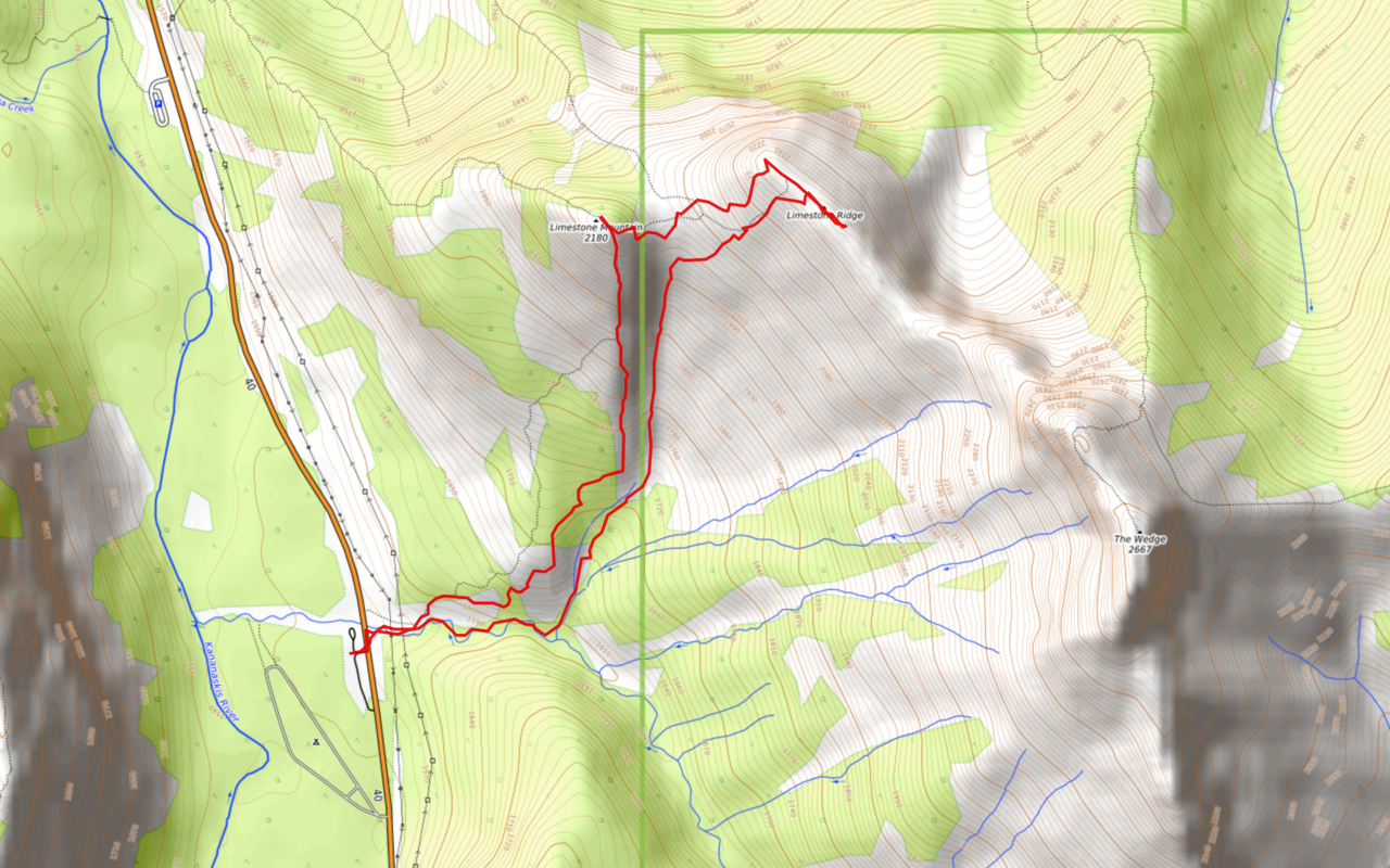
Limestone Mountain and Ridge Route Map (see link in desciption - or click here - for interactive version).

From the summit of Limestone Mountain we had to descend to the col, down to the east, before reascending to Limestone Ridge. This began by retracing our steps a short ways back down Limestone's summit ridge, before finding the first obvious weakness leading through the summit cliffs on skier's left. (Approximate route up Limestone Ridge, once across the col, is shown.)

Looking back to the summit cliffs. The weakness is the narrow, snow gully just right of the bigger snow patch.

Met a nice mountain goat along the way.

Posing for a picture 😉

The next step between us and the col wasn't quite as straightforward...

After scrambling down a short section, we found ourselves on a narrow ledge, with a vertical cliff directly below! My dad traversed the ledge to skier's left, while I went right to look for a weakness.

My ledge soon came to an end, where the only option was to downclimb this narrow crack, angling through the cliff band. It looked do-able, so I gave it a go, and made it through!

After reaching safety, I traversed back below the cliffs to see if my dad had made any progress on his route. He stood above a steep snow gully, contemplating a descent. The gully was very steep, and we didn't know what kind of rock hid beneath the snow, so we decided that it would be best if he traversed back along the ledge to try my route.

My dad carefully descends the crack. The rock above the crack is overhanging which doesn't help matters much...Based on Nugara's description, I'm sure that there's an easier route, but it was likely covered in snow for us.

It's all up now! Once through the cliff band, it's smooth sailing to the col on scree/snow slopes. Unfortunately the forecast didn't lie, and our sunny blue skies were quickly being lost to grey cloud as a snow storm rolled in.

Starting up Limestone Ridge's lower scree slopes.

Looking back, as my dad approaches the first section of slabs.

Ascending the slabs. After traversing under them, to climber's left for a short distance, there's an obvious route up on a variety of scree covered ledges.

Close up of our route down the upper section of Limestone Mountain.

Once above the first short section of slabs, the terrain degrades to a stretch of loose scree.

Limestone Mountain looks so small now!

After gaining the majority of the elevation on scree, there's one last short slab guarding the summit ridge.

Long ways down to Wedge Pond!

Where'd those blue skies from earlier go? :(

Incredible view of the clouds lifting from Mount Denny!
Silhouette among the clouds.

A brief window reveals a piece of Mount Lawson's long, south ridge.

Still got a short ridgewalk to the summit.

My dad steers clear of big cornices, as he approaches the summit of Limestone Ridge.

Upon reaching the summit, we were met with this incredible view of The Wedge, it's summit still hidden by low cloud.

My dad stands proudly on the summit with his "god stick"! LOL. Oh yeah, I forgot to mention that...My dad really hates slabs, but he happened to find this random stick along the way and claims he felt better with it...Idk man ¯\_(ツ)_/¯

Old Baldy, McDougall, Volcano, and two surprisingly unnamed peaks make up a grey view to the northeast.

The highest of the bunch, Old Baldy Mountain.

We watched in awe, as the clouds slowly lifted from The Wedge, revealing its entire slabby, west face!

Summit selfie!

Zooming-in to The Wedge's daunting form.

Neat cloud formation happening here!

I continued southeast, along the ridge, for a short distance to get an even closer look at The Wedge. Photo credit: Dad

Dense clouds surround the Kananaskis Range, focussing in on The Fortress in the center of the frame.

Fortress, Gusty, and Galatea. Three impressive peaks which are all scrambles!

Yet another close up of The Wedge! The ridge narrows significantly after this point, and as there were still cornices to contend with, we decided we didn't need a closer up close-up 😉.

Opal Ridge's north end stands out against the storm.

Looking back to the impressive summit cornice!

A somewhat cleared up view towards the Kananaskis Range, with Limestone Mountain below, right.

One last view of you-know-what before leaving.

Heading back to the summit.

On descent, we dropped down slightly earlier, and descended loose scree slopes, east of our ascent route. If you're looking for the easiest option, this would be it, as it completely avoids all slabs.

Looking up the slope.

We soon reached the tree line, where snow still remained. Even though we put on microspikes, this slope was steep, and nearly rock hard, making it kinda sketchy to descend. Especially because we had no means of stopping ourselves (ice axe) in the case of a slide...

To our relief, the snow (ice) eventually gave way to rock, and we continued angling southwest, towards the gully that leads down on the south side of the col. Note that there is no need to reascend Limestone Mountain, unless the creek is too high that is...Make sure to check when you start out if you're planning to use this alternate descent!

Although there wasn't quite enough snow left for a glissade, the snow down in the gully was much softer, and was a blast to run down!

We made it down the snow-filled gully in no time, and noticed this near the bottom...

Looks like a significant avalanche happened here not too long ago! Maybe not such a good idea to be in this gully when there's snow around...This route would present severe avalanche risk when the sides are snow loaded in winter!

Once over the heaps of avalanche debris, the gully narrows and becomes bushy for a short section before joining with the creek.

We soon emerged at the creek, which can simply be followed back to the highway where we started for Limestone Mountain earlier.

Neat lil' icicles in the creek.

As we leisurely made our way down the creek we soon found ourselves in a full on blizzard...Well, at least creek crossings weren't a problem ;)!

Back to where our ascent and descent routes meet. If ascending Limestone Mountain, a faint trail enters the trees on the left, while the wide creek on the right can be used as an alternate descent if water levels permit. Although a small mountain, Limestone presents some big views, and makes for a relatively short and enjoyable scramble, especially when combined with Limestone Ridge! This short, little scramble may have gotten me excited for scrambling season, but there's still snow on the ground, so we might as well go make some use out of it! Even if the quality ain't so great...
Disclaimer