
Date: June 28, 2022
Location/Route Map: Kananaskis Valley
Elevation: 2758 m
Elevation Gain: 1360 m
Distance: 18.3 km (round trip, including Allan and Olympic Summit)
Rating: Class 3 - Moderate
Notes: One moderate cliff band along Collembola's north ridge, which can be troublesome early season if snow lingers.
GPS Track: Download
After completing the traverse from Gap to Fable the previous day, we made the last minute decision to cross off another traverse that's been on my "hit list" for a while! Hey, it's not every trip that we have the luxury of starting and ending in different spots with our car magically waiting for us! (thanks mom :)!) Today's lengthy traverse would hit three peaks (Collembola, Allan, and Olympic Summit), and take us all the way from Deadman's Flats (near Canmore) to Kananaskis Village! While I knew that the Centennial Trail (known for being the highest maintained trail in the Canadian Rockies!) easily paves the way up Allan and down to Kananaskis Village, I wanted to include Collembola, and was therefore going in partially blind. I don't know why, but for some reason I had it in my mind that Collembola was just a hike like the rest of the traverse...Spoiler alert: It's not!
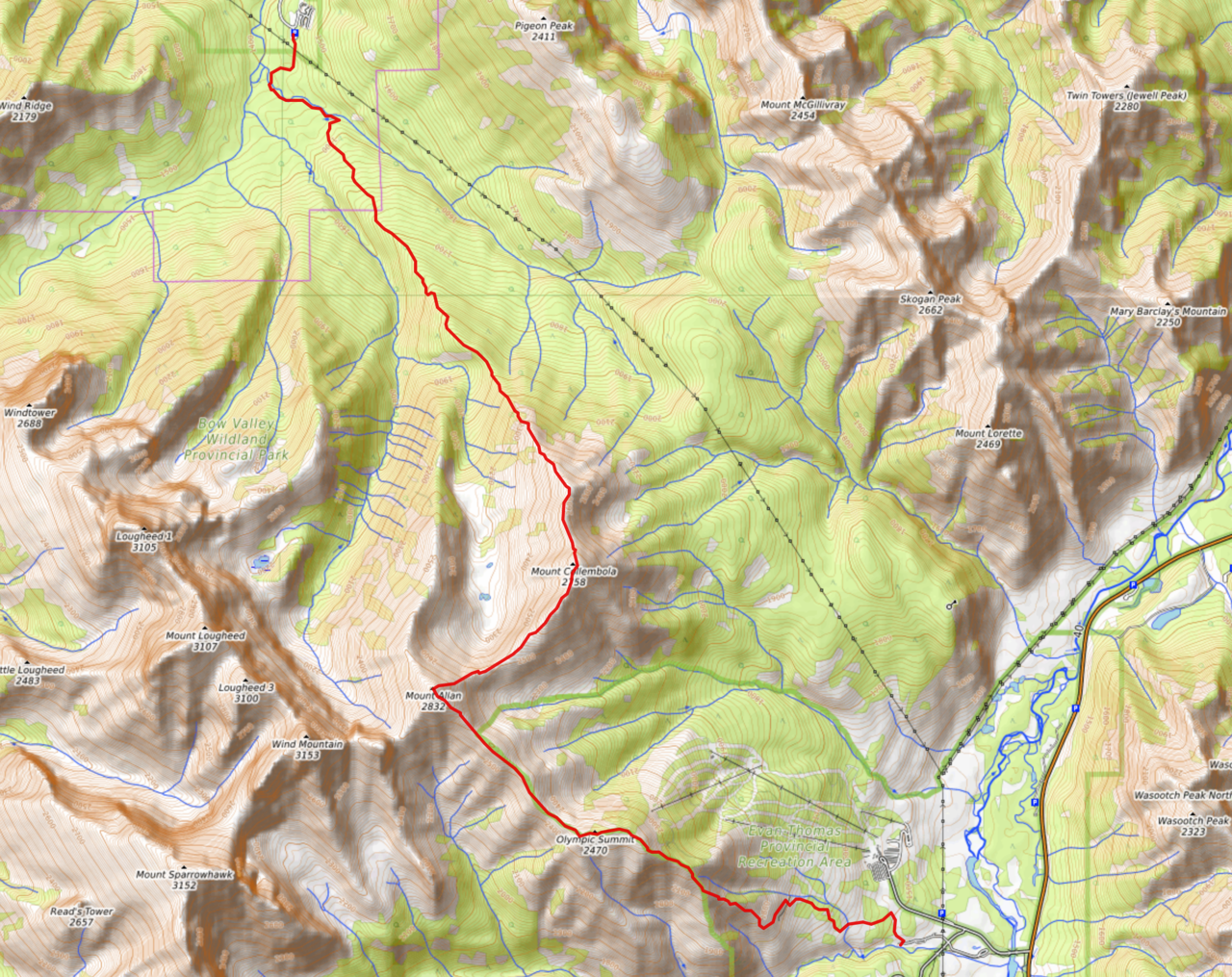
Collembola, Allan, and Olympic Summit Traverse Route Map (see link in desciption - or click here - for interactive version).

From the parking lot, we easily started up the wide Centennial Trail. After about 800m (just after crossing Pigeon Creek), we were met with a junction that had us a little bit confused...While the obviously maintained trail, that we were following up to this point, curves up to the right, the Centennial Trail is actually the narrower, slightly overgrown trail that stays along the creek. Took us a little while to convince ourselves we were going the right way. LOL!

Wildflowers :)! While not quite as maintained as the other trail, the Centennial Trail is still wide compared to the trails I'm used to, and we were sweating hard as we powered our way up the initial ~6km approach to the base of Collembola. With such an obvious route, we had nothing to think about except speed! 😏

The terrain soon became more ridge-like, and a cutline allowed us to catch a glimpse of Lougheed's sheer east face.

The lower slopes of Mount Collembola rise above the forest. Don't be fooled (like I was); the summit is still quite a ways off!

You'll have to keep an eye out, but eventually a narrow, bushy trail (not maintained) branches off from the Centennial Trail (maintained) just as you start traversing the hillside towards the cirque between the two mountains. If you're wanting to bag Collembola, like us, this is where you'll want to go. If not, continue on your merry way, and the highest maintained trail in the Canadian Rockies will take you right up to the summit of Mount Allan!

Now this is the kind of trail I'm used to! 😂

The bushy trail didn't last for long, and we were soon climbing past the treeline, enjoying our first views back towards Canmore.

Lougheed 1 is impressive...as always ;).

While Mount Lougheed's official summit is often blocked out by the aforementioned Peak 1, it definitely makes a statement from this angle!

Starting up Collembola's uniquely grassy, lower slopes.

Expecting this to only be a hike, when we reached the first minor rock band, we traversed around it to climber's left.

Coming around to Collembola's crumbly, east slopes.

We immediately determined that traversing the eastern slopes was definitely not the way to go, and scrambled up easy to moderate (depending on route) "steps" back up to the ridge. Photo credit: Dad

Looking back down the approach.

My dad follows me back up to the crest.

Back on the ridge! Check out those neat clouds!

Our first view of Mount Allan, rising across the cirque, to the right. We've still got a long ways to go!
The Three Sisters rise in the background (left) as we easily continue up the ridge.

I was still convinced that this mountain would simply be a hike at this point...

Mount Bogart peeks out to the left of Allan.

Pigeon, McGillvray, Skogan, and Lorette rise across the cutline to the east.

Interesting lighting on the distant front range.

Close-up of Lougheed's four impressive peaks: Wind Mountain, 3, 2 (official summit), and 1!

Storm incoming!! Note Mount Alymer, randomly lit up on the right.

After a leisurely ~2km of grassy ridgewalking (after the first rock band), Collembola's summit comes into view!

Uhhh...this wasn't part of the plan! As we neared the summit, a significant cliff band appeared, and as hard as I analyzed, I saw no weaknesses through it! Maybe I should of done more research...¯\_(ツ)_/¯

Not about to give up without taking a closer look, we started up the steep, soft scree below the cliffs, aiming for the ridge crest. I desperately hoped that the eastern slopes would present some possibilities...

SHOOT! My heart sank as I came up to the ridge, only to discover that the eastern slopes were still loaded with hard, icy snow, exposed to a steep slope below! I stood there for a moment in dismay, but we'd already come all this way, so you better bet I still wasn't about to give up! The storm that had been lingering around all morning finally decided to hit us (perfect timing...😑) and the wind picked up, pelting rain at our faces and making the rock slick! Definitely not ideal conditions for route finding, but despite all this, I was still determined, and went to stick my nose into the blocky cliffs ahead (note my orange backpack, almost at the top of the rock band). Photo credit: Dad

An idea of the approximate route I took.

After reaching the top of the band (moderate scrambling when dry; a little bit sketchier when wet!), I coaxed my dad into following me, even though he was reluctant given the current conditions. Waiting at the top, completely exposed to the rain, I got soaked pretty quick, and was pretty chilled when he finally joined me.

All that was left, once up the cliff band, was an easy (and once again grassy ¯\_(ツ)_/¯) hike to the summit!

While the rain had eased off, the views still took a significant hit, and we didn't linger long before continuing our traverse.

Mount Kidd, Kidd South Peak, Fortress and Chester (distant), Ribbon Peak, and Mount Bogart line up to the south.

Mount Sparrowhawk and Wind Mountain tower beyond modest Mount Allan.

Closer look at the mighty Mount Bogart. It's been on the list for a while...I'll get it done one of these days ;).

Mount McGillvray gets its own, personal cloud.

Pigeon's grassy slopes add a much needed splash of colour.

Not much else to see, so off to Mount Allan it is!
Disclaimer