
Date: June 28, 2022
Location/Route Map: Kananaskis Valley
Elevation: 2470 m
Elevation Gain: 1770 m (50 m from Mount Allan)
Distance: 18.3 km (round trip, including Allan and Collembola)
Rating: Class 2 - Easy
Notes: A simple hike along the Centennial Trail.
GPS Track: Download
After reaching the apex of our traverse, all that was left was descending the ridge to the southeast, towards Kananaskis Village. A small bump sits near the south end of the ridge (to put size into perspective, the gain to reach it from Allan is only about 50m 😂), and although it barely deserves the title of a summit, "Summit" is right in the name! I don't know about you, but that's reason enough for me to add it to the count ;)! After already being hit by two rain storms, we thought that the worst was behind us, and started down the ridge in high spirits, ready to bag our third summit of the day...
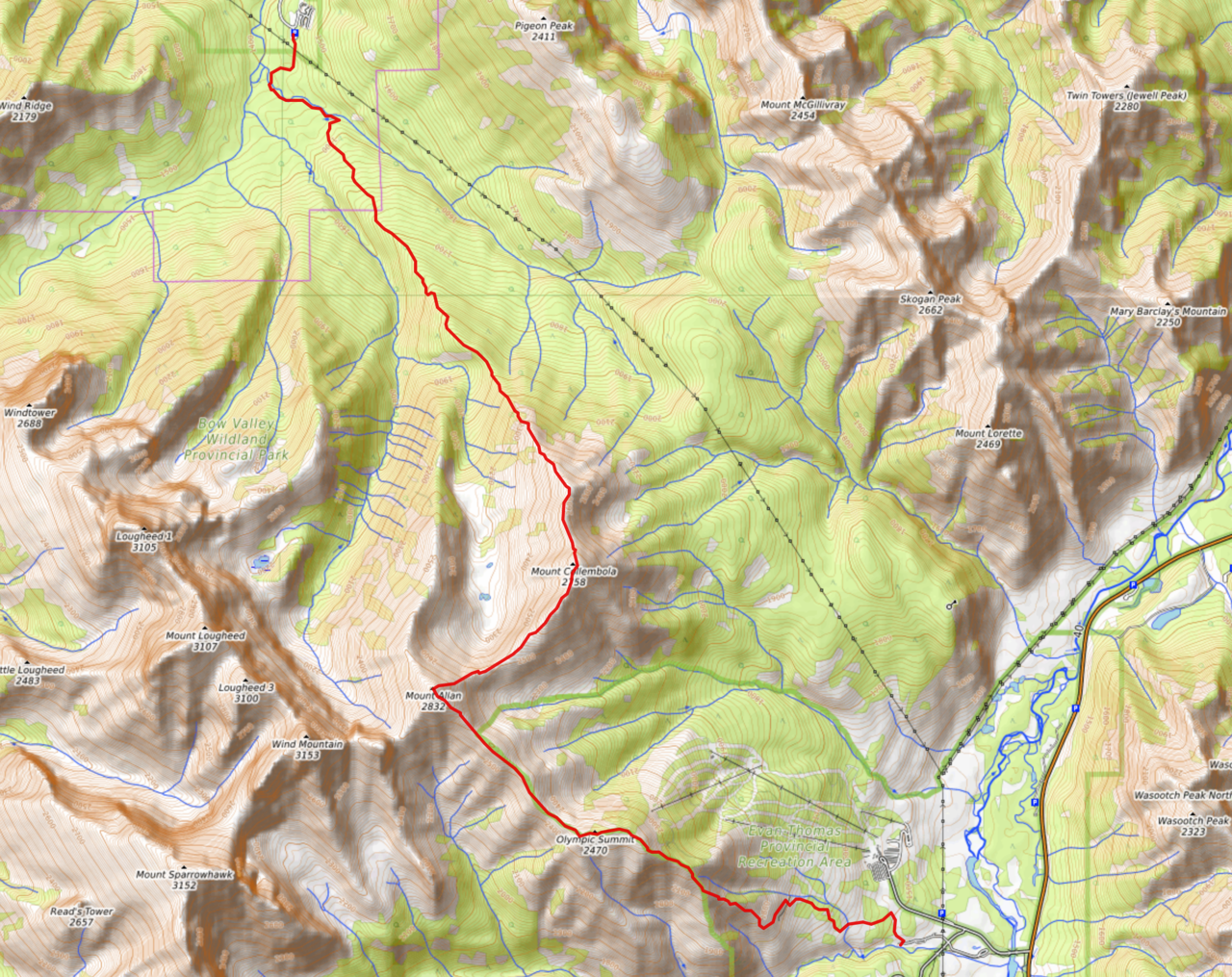
Collembola, Allan, and Olympic Summit Traverse Route Map (see link in desciption - or click here - for interactive version).

Starting down Allan's southeast ridge towards Olympic Summit (flat ridge, center).

Lots of incredible walls of rock in the area! Lougheed's east face was stunning, and the ridge connecting Bogart and Sparrowhawk is no different!

Looking back up to Wind Mountain.

Oh no! Those clouds don't look too friendly! Bogart rises over Ribbon Peak and Bogart Tower.

A little bit of urgency creeped into our pace, as the weather took a turn for the worse for the third time!

Approaching the peculiar "rock garden". Note the orange marker (center), a collection of which mark the way.

My dad continues down the trail through the rock garden, giving perspective to these giant rocks!

This pinnacle in particular caught my attention.

Rip...Just like that, the rain came pouring down, and we were stuck in the worst storm of the day! Luckily we hadn't quite passed the rock garden, and took shelter against some big boulders. Even so, we were still high on the mountain, and this was a full on storm, complete with booming thunder and lightning! I can't say we felt the most safe in our position...

The end is in sight!

Luckily the trend of "speedy storms" continued, and after about 20 minutes in hiding, we felt safe enough to continue down the open ridge, soon accompanied by warm sun, and bright rainbows :)!

Approaching the low point before the final "climb" up to Olympic Summit ;). Note the MASSIVE storm clouds moving to the east! (Those were right over our heads just moments ago!!)

Neat angle of Mount Sparrowhawk!

Ribbon, Bogart and Sparrowhawk from left to right.

Looking back up the ridge to Allan (left) and Collembola (right)!

Zooming-in to Mount Collembola.

Pretty lighting on McGillvray, Skogan, Lorette, and Baldy (distant).

Approaching one of multiple cairns along the ridge. I have no idea which one's the highest ¯\_(ツ)_/¯.

A rushed summit selfie on one of the many minor highpoints along Olympic Summit! The wind was starting to pick up, and more ominous storm clouds were rolling in for the fourth time!! We started running down the ridge to hopefully reach the treeline before the storm reached us!

McGillvray is the last peak to hold out, as darkness approaches.

The rain started to fall just before we reached the steep treed slope at the end of the ridge, and we were able to continue down in the partial shelter these trees provided.

Looking back up the treed slope. In contrast to the cliff-like appearance, a trail easily leads through.

Unfortunately the ridge was still open and exposed to the elements, even though we'd hit the "treeline". We tried to continue nonetheless, but the wind was gusting so strong that the rain was moving across the ridge in horizontal "sheets" and we were forced to take cover behind some rock outcroppings once again.

We tried to make a run to the next sheltered location, but didn't make it far 😂.

The Wedge and Opal North Peak appear as the storm eases off.

It's a pleasant trail when there's no wind trying to throw you off the mountain ;).

Blue skies!!

Beautiful lighting on Kidd South Peak's impressive north face!
I absolutely loved the sunlight illuminating sections of the grassy slopes!

Mount Kidd towers above.

Green pyramid :)!

Crazy dark skies, looking across to Wasootch Peak, Kananaskis Peak, and Old Baldy!

Continuing down the ridge, surrounded by my favourite views of the day! Good lighting really makes a difference!

Double rainbow!!

Fisher Peak is completely cleared off for the first time all day!

Those storm clouds are insane!

We soon reached the forest, and simply continued down the Centennial Trail all the way to the Ribbon Creek parking lot, where my mom was conveniently waiting for us with our car :)! What a productive day! Hit three summits, walked from Canmore (Deadman's Flats) to Kananaskis, and survived four storms along the way ;)! It was great to finally do this traverse, and I would definitely recommend it if you have a ride...(Walking all the way back to Deadman's Flats would leave you feeling like quite a "dead man"!) Just know that Collembola isn't just a hike like the rest of the traverse 😂!
Disclaimer