Date: August 28, 2023
Location/Route Map: Siffleur Wilderness
Elevation: 3221 m
Elevation Gain: 1850 m
Distance: 13 km (from camp in Siffleur's southern hanging valley, to summit, to camp in Loudon's southern hanging valley)
Rating: Class 4 - Difficult
Notes: This is a big, remote mountain that requires not only a high level of perseverance and grit, but also competent route-finding and scrambling skills to reach its summit.
GPS Track: Download
Making the long, exhausting trek up the Siffleur River "Trail" and ascending Siffleur Mountain on day 1 was just the beginning, and the second day of our trip would only take us deeper into the backcountry, and with that, the unknown. Our ascent of Siffleur Mountain felt almost a little too easy, benefiting from very recent beta shared to the online world by Vern just one month prior, but now it was time to truly put my route-finding skills to the test on the elusive Mount Loudon, and for this beast of a mountain I was going in almost completely blind. Finding information on Loudon is no easy task and after scouring the web in the usual places the only information I was able to come up with was the following account from Rick Collier, who made the second recorded ascent all the way back in 1998:
"The next day we thrashed up Porcupine Creek for a kilometre and then diagonalled up the S slopes of the objective, heading toward the first major N/S drainage, which we intersected at 388496. We crossed the jumble of..."
The jumble of what?!! Damn Rick, you really gotta leave me hanging like that? LOL. One of these days I'll cave and finally sign up for paid member access, but today's not the day! Jokes aside, this cliff-hanger of a description did provide me with some valuable information. I now knew with relative confidence that I could access my objective via Porcupine Creek (and likely the southern hanging valley), but the actual ascent of Loudon, now that was something I'd have to figure out on my own.


We woke to a beautiful, blue bird morning in the hanging valley below our previous days' objective and didn't set off until around 08:00 after lazily packing up camp and loading up with water for what was bound to be another HOT one. The sun was just cresting over Siffleur's lower SE ridge, illuminating the valley in a sea of warm, golden light and as hard as it was to pull ourselves away from this small piece of heaven, we had another big day ahead of us and we were already starting it a few kilometers behind schedule.


Neither of us were too keen to repeat the sidehill that initiated my dad's knee pain the previous afternoon, so we once again followed in Vern and Wietse's footsteps, exiting the hanging valley on the opposite (west) side of the abuting ridge.

While the steep descent of loose rubble on dirt/grass slopes that ensued didn't turn out to be all that friendly to my dad's knee either, we made it down to the next valley over without too much difficulty and were soon rejoining our ascent route to lose the final 300 meters of our hard earned elevation, right back down to the overgrown cutline along the Siffleur River.

As we continued along the cutline towards Porcupine Creek, we remarked just how strange the thing was. Such a prominent, perfectly straight line, right through the middle of raw, untamed wilderness in one of the more remote valleys of the Rockies. It felt so wrong, out of place, and honestly a little bit eerie. When was it made? How was it made? Why was it made? I had so many questions!


There was only one thing I knew for certain and that was that it's definitely been out of commission for a while! Nature is once again showing who's boss as it slowly reverts the forest back to what it once was, and we eventually ditched the bushy, deadfall-ridden cutline in favour of the steeper (cleaner) slopes to our right, ascending up n' over a grassy hill where a fast flowing Porcupine Creek was waiting for us.


The "thrash up Porcupine Creek" was exactly that - a thrash. Mother nature has been busy since the 2018 wildfire and lots of young growth has already filled in the gaps between the thousands of charred "pick-up sticks" littering the forest floor. As we slowly picked our way alongside the creek I couldn't help but wonder what this forest had looked like during Rick's 1998 ascent. Had the fire helped or hindered passage?


After about 800 m of painfully slow travel, wading through fireweed and balancing over fallen log after fallen log, I felt like I had my answer. There was no way this could possibly be an improvement! We topped up our water supply one last time and collectively decided that we'd had our fill of Porcupine Creek (both literally and metaphorically 😂) and began our angling ascent up Loudon's lower, southern slopes.
The steepness ramped up quickly as we set a NW trajectory, aiming to intersect the "first major N/S drainage" at the entrance of the upper hanging valley. Views continued to improve as we climbed, with Quill's unnamed NE outlier stealing the show - it's north face rising vertically from the opposite side of Porcupine Creek - but these views were thanks to the openness of the burn and with this open, southern exposure also came heat...30+ degrees of it!


Thankful to be free from the Porcupine Creek "obstacle course", all we had left to think about was putting one foot in front of the other as we dragged our heat exhausted bodies upwards, and eventually found ourselves approaching the "drainage" Rick mentions - only we were about a hundred meters above the drainage part...
Instead of the hop, skip, and a jump over a creekbed that I was expecting, what we were faced with was a steep, concrete-like, cheese-grater of a slope that we'd have to traverse in order to gain access to Loudon's southern hanging valley. I know terrain like this doesn't inherently look that dangerous, but it should not be taken lightly! It's hard to feel secure when you can't dig your feet into the slope and if you take a tumble here I guarantee you'll be coming away with some nasty "mountain road rash" - at BEST!


We briefly considered descending in the burn, crossing the drainage where it narrowed, and continuing up on the opposite side, but that kind of extra work for a route that might have worked was even less appealing at this point in the day, so we sucked it up and began the delicate traverse. I wouldn't even think about doing this without a solid pair of trekking poles in hand and even so, this slope demanded our full concentration to safely cross! We breathed a sigh of relief when the cement beneath our feet finally broke up into more forgiving scree and wondered what other challenges this mountain had in store for us as we entered the hanging valley.

When planning my proposed route for Loudon, I was presented with three main options: the southeast ridge, the south basin, and the southwest ridge. I was quick to discard the SE ridge thanks to the contours depicting a very major cliff band (confirmed in an image from Vern's Mount Fuhrer report), which narrowed it down to two choices. The SW ridge looked the most promising based on topo and satellite imagery, but I was personally hoping that we'd discover a more direct line, straight up the south basin, breaching it's wall of cliffs via a secret scree gulley/ramp that wasn't major enough to show up on maps. Now on location, however, I gazed up at the vertical wall guarding the head of the basin and it immediately became clear that we had one option and one option only - the SW ridge.

I was both excited and nervous to start up my exploratory route, but first we had a serious problem to address, and that problem was water. We'd been hiking in direct sun for hours since our last water source down at Porcupine Creek and we still had one vertical kilometer of south-facing slopes to go! I was counting on finding a small outlet stream at the mouth of the hanging valley, but unlike Siffleur, this valley was 100% bone dry. I convinced myself that I could ration what little water I had left, but my dad kept things real and made it clear that this would be the end of the road for him if we didn't find some fluids.
We knew that the water flowing a couple hundred meters below us in the "drainage" we'd just crossed had to have come from up here somewhere...all we had to do was find it! As we started our search up the valley, we were soon engaging in our first hands-on "scrambling" of the day - navigating our way through a huge field of house-sized boulders - and as much of an inconvenience this was given our "where's waldo" (water) situation, I couldn't help but marvel at the otherworldly terrain this valley held!


The faint sound of trickling water taunted us as we scanned the barren landscape for the slightest glistening of moisture, and our hearts sank as we reached a raised "platform" in the middle of the boulder field, coming to the realization that the only water in this desert valley was a minor waterfall, trickling down the cliff face high above, before disappearing under the heaps of rubble. RIP.
I knew we didn't have much of a choice at this point and volunteered to be the one to add the extra hundred or so meters of scree bashing to my day. With nothing but my 3 liter water bladder slung over my shoulder, I reluctantly set off on my water-retrieval-mission, but I barely made it 20 steps before I saw it! Right there, seeping out from under a boulder, was a miraculous gift from the mountain gods - WATER!! I couldn't believe my eyes!


I excitedly waved my dad over and we eagerly started filling our bottles from the tiniest spring I've ever seen! - This was actually a very slow, complicated process, and while I'm not going to dive into the details, let's just say the water was no more than a couple centimeters deep and had almost no flow...Anyways, after wasting almost a hour with our whole water endeavor it was finally time to see what the SW ridge was all about!

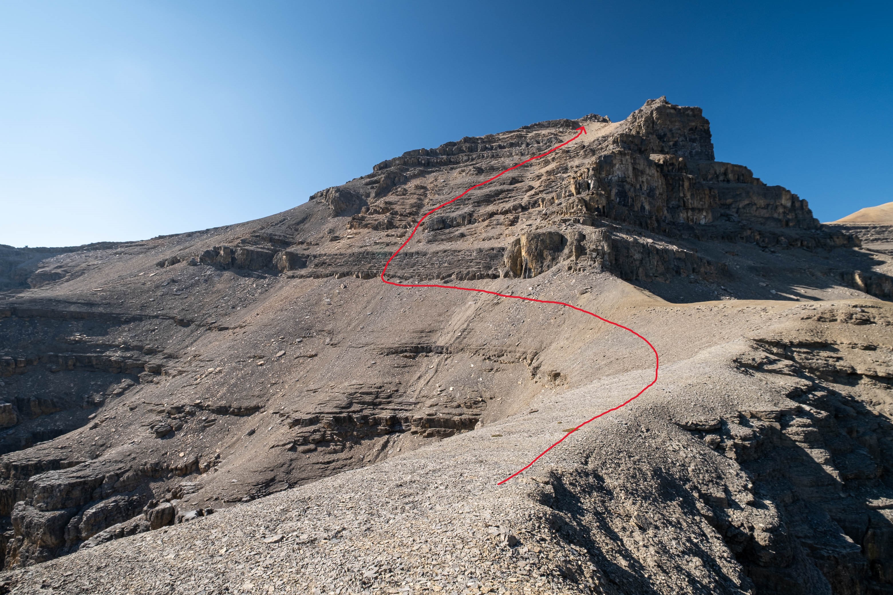
We gained the lower SE branch of Loudon's SW ridge by taking a direct line up the steep scree slopes on the left-hand side (climber's) of the basin. This 300 meter slog up loose rubble was draining to say the least but at least it wasn't cement, so that was an improvement! As we topped out on the ridge I was once again blown away but the geological features of this mountain. The views across the hanging valley to Loudon's colourful walls of limestone were stunning, but what impressed me even more were those house-sized boulders, now defying gravity as they balanced precariously on the ridge! Geologists would loose their minds over this stuff! (Maybe...I don't know any Geologists actually, so I'm just speculating here 😂)


After finding a safe place to dump our overnight gear (we forgot to leave it down in the hanging valley after all the water "excitement"), we continued up the boulder field (i.e. the lower SE branch of Loudon's SW ridge), easily bypassing an impressive outcrop on climber's right, before coming face to face with a steep, broken cliff band. It looked pretty daunting from afar, but upon closer inspection I started picking out a few possible lines and got right to it, excited to finally get my hands dirty after two long sloggy days!

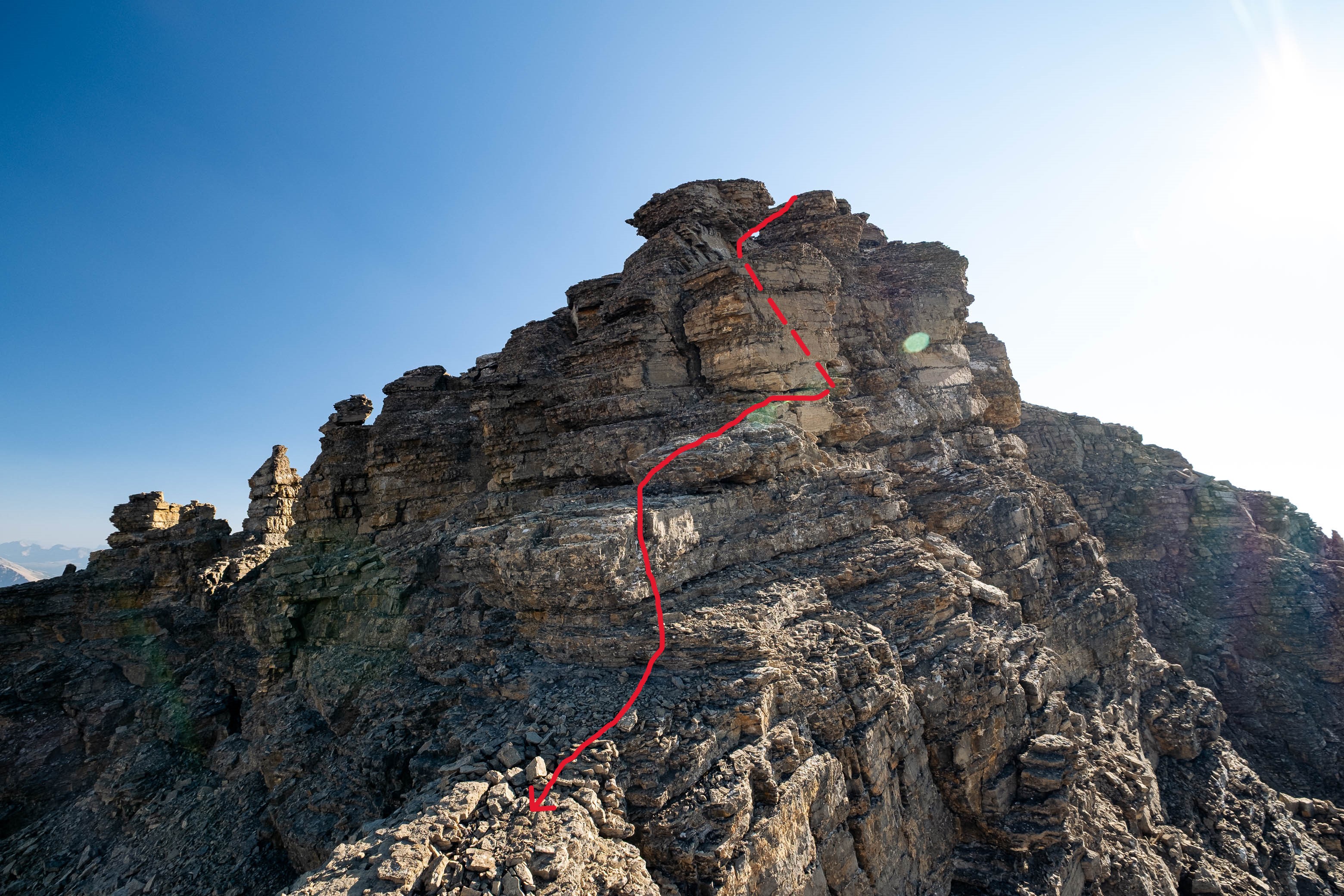
I started by ascending the first obvious weakness up loose, crumbly rock, before making a short, downsloping traverse to climber's left and continuing up a chimney that easily led me to a broad scree ledge about halfway up the wall. My dad wasn't willing to commit to the final move of the first weakness on questionable holds, but luckily I was able to find him a bypass using a narrow flake to climber's left.


We traversed along the broad scree ledge (back to climber's right), looking for a weakness in the vertical wall that now blocked our path, and I made the mistake of being a little bit too eager, picking a line up the wall as soon as it became slightly less vertical and "climby" looking. While I made it up this step without too much difficulty, downclimbing it was not something I liked the thought of and cautioned my dad not to follow me. I went searching for an alternative route and got lucky again, discovering a narrow gully/chimney feature just around the corner, to climber's right. After making sure I could downclimb this one, I called my dad over and led the way back up to the next ledge. Unfortunately the lack of foot holds at the bottom of this weakness necessitated a big reachy step as its first move - something that my 6' frame could handle, but my dad's 5'9" frame could not. After resiliently fighting through knee pain all day, my dad decided he'd finally reached his limit. It was now 16:30 with the summit still a long ways off and after agreeing to a "what if" plan he started back down to wait at our gear while I began my race against the clock.


As I traversed back to the left, I started to wonder if I'd be joining my dad sooner than later...The final overhanging wall that loomed over me didn't look like it had any intentions of letting me pass, but then I got incredibly lucky for a third time! Just as I reached the end of the ledge, the intimidating walls parted, forming a narrow crack that allowed me to waltz right through! The mountain gods were smiling on me today 🙂!


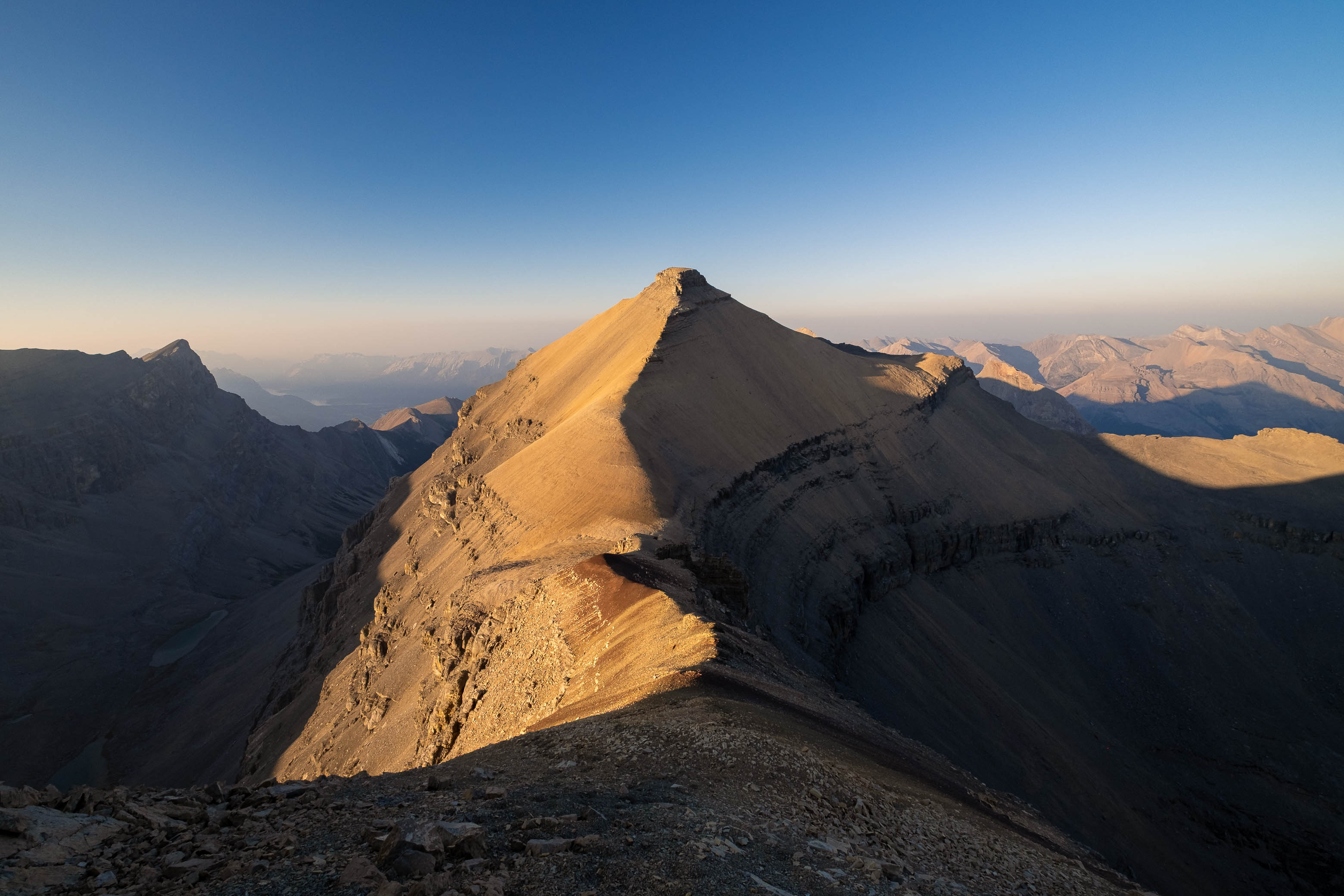
After successfully solving this first puzzle, it was right on to the second as Loudon's 3100 meter false summit reared up in front of me. I knew that every minute I wasted meant another minute of my dad waiting and worrying, and this thought alone was enough to push me into a higher gear as I powered off towards the next obstacle. I quickly picked out a direct line up the stepped terrain ahead, traversed a short distance below the first set of cliffs, and crossed my fingers as I started the loose 400 m grind to the false summit, desperately hoping my route would work.

My chosen route worked like a charm and my only real obstacle was gravity, dragging me, and the rocks beneath my feet, down the mountain as my jello-like legs tirelessly fought their way in the opposite direction. I only allowed myself brief "picture pauses" before getting right back to business and was feeling pretty good about my progress as I topped out on the false summit less than an hour after splitting up with my dad.


After taking a couple minutes to catch my breath and admire the views from this already incredible vantage point over 10,000 ft, I turned my attention back to the task at hand - Loudon's summit pyramid.

Even though I only had to drop about 100 meters down to the col between the false and true summits, losing any amount of my hard earned elevation was a major blow at this point in the day, and I tried my best not to think about having to re-ascend each and every step in a couple hours time as I slowly started jogging down the gentle ridge. My eyes were drawn to Loudon's intimidating summit block as I descended from the false summit, and I found myself already thinking one step ahead, scanning the cliffs for possible weaknesses and wondering if they were as troublesome as they looked from afar. Aside from this final puzzle that I'd have to solve, I was genuinely starting to feel like I had this ascent in the bag!
Until I didn't...
What started out as the most innocent scree slope I'd ever seen, abruptly crumbled away to a narrow, rotten ridge of precariously stacked blocks, and with steep drops down to the valleys on either side, any confidence that I had building just moments ago was wiped away in an instant. I gazed longingly across the ~ 100 meters of gnarly terrain to the once again benign ridge below, but ultimately knew at first glance that this was way above my pay grade, especially solo. Loudon's summit block, that seemed just out of reach moments ago, now felt miles away, but I'm not one to give up without a fight, and decided to see if a route traversing the incredibly steep and loose, downsloping ledges on the right (south) side of the ridge would go.


Stemming down a small chimney feature took me down to the first of these ledges, but I didn't make it far. The terrain was simply too steep, too loose, too exposed, and too broken to safely continue. UGH!!! The clock was ticking as I scampered back up to the ridge to reset and re-evaluate my options. If I wanted to make this summit I did not have time to be messing around! I took one look along the left (north) side ledges before quickly ruling them out (if anything they looked even worse than the route I'd just attempted!), and was back at square one, gazing across that extremely uninviting ridge and wishing I was on the other side of it. As much as I wanted to deny it, the reality was starting to sink in. I wasn't going to be standing on top of Mount Loudon today. My luck had run out.
If you've ever been turned back on a big mountain before, you know the feeling. I thought about all the hard work and suffering it took to get to where I now stood, and the thought of going home "empty handed" after coming this close was absolutely crushing. I snapped my last few photos of defeat, before preparing for an early reunion with my dad, but as I took one last long look along the broken terrain that lay before me, I just knew I would never forgive myself if I didn't at least give it a try. I mean hey, maybe it wasn't as bad as it looked, and the only way I'd be able to put my mind at rest is if I actually went and stuck my nose in it!
Poles strapped to my pack, I gingerly started down the literal dragon's back, and was almost immediately faced with my first crux - a 3 meter overhanging drop. There was absolutely no way I was downclimbing that, but there was a narrow chimney leading down on the left (north) side of the ridge that didn't look impossible, so down I went! After descending a couple meters, the chimney cliffed-out and my only option was to traverse a narrow ledge (more like a crack that I could only fit the toes of my boots on!) across a vertical wall to rejoin with the ridge crest. It was a very short move, but it was also a very exposed one, and a mistake here was not an option!

I breathed a sigh of relief after making the last reachy step off the ledge, and hoped the worst was now behind me...NOPE! Mere seconds after completing this first crux I was met with a second - another (smaller) overhanging drop. This time I descended a short step on the right (south) side of the ridge before, once again, completing a narrow ledge traverse back to the crest. This ledge was just as exposed as the first one, but the rock here didn't feel as solid and I focused 100% of my energy on each methodical foot and hand placement, being "one with the mountain", as I tip-toed across.


As incredible as it is to look at (when you're not clinging to it for dear life!), the crumbly, precarious nature of this ridge was in no way confidence inspiring and these two crux steps were well near the limit of what I was willing to risk alone in my current heat and mentally exhausted state. I felt like it was only a matter of time before I reached a dead-end as I continued balancing my way along the "floating sidewalk", but somehow, step by step, the route continued to go, and before I knew it I was standing on the other side of the impossible ridge. I couldn't believe it!
I was beyond stoked about my accomplishment, but there was no time to celebrate. Loudon's summit block now rose over 200 m above me, looking as daunting as ever, and I still had no idea how I was going to breach it. Based on the aerial map on my phone, the back (east) side of the summit block appeared to present a potentially cliff-free route to the top, but so did the south side (which I could clearly see was not the case), so I wasn't fully convinced...


It was 18:00 as I started up on the opposite side of the col and I knew I'd run out of time if the first route I chose didn't work out. It was a gamble, but the western cliffs just weren't presenting any obvious weaknesses the closer I got and I decided to pull the trigger on the roundabout traverse route, hoping I'd get lucky - One. Last. Time.
My body was feeling it as I left the solid ridgeline and immediately found myself fighting to gain (or even just maintain!) elevation as I began the treadmill traverse below Loudon's southern summit cliffs. I hadn't eaten since we stopped for breakfast down at Porcupine Creek and was majorly dehydrated, rationing what little water I had left by only taking a few tiny sips per hour to try (unsuccessfully) to provide some relief to my chapped lips and extremely dry mouth.


I held my breath as I rounded the summit block on its east side - Did I guess right or would this mountain be sending me home once and for all?! - and almost jumped for joy (I probably would have if I wasn't running on fumes) when I found the most innocent of rubble slopes, gently leading to Loudon's broad summit plateau!


As I made the final few steps to the summit cairn I was hit with a wave of emotions. After coming so incredibly close to turning around, I was actually about to stand on the summit of this mountain!! I dropped my pack at my side and just stood there in a daze for a few minutes, admiring the far-reaching, albeit hazy, evening views, feeling so incredibly lucky to be standing atop such a big and remote peak. There truly is nothing like exploring the unknown and stepping foot where only a handful of humans have ever been before! It's moments like this that make life worth living!


I excitedly opened to the first page of Rick Collier's original 1998 summit register to learn that the F.A. was in 1972 by A. M. Daffern and Miss A. Ridley, followed by Rick Collier and Reg Bonney's second recorded ascent 26 years later in 1998. Could mine be the third, after another 25 year gap?!...I flipped to the next page and my jaw dropped. I was beat again!! I already knew about Siffleur beforehand, but this one was a real shocker! Just a couple weeks prior, Eric Coulthard and Doug Lutz (two big names in the scrambling community) had snatched the third recorded ascent away from me, approaching Loudon from the west via Totem Creek! No ascents in over 25 years and then two within a couple weeks?! UNREAL!
After adding my two bits to the log book, I quickly snapped a few pictures before packing up and promptly starting back down the mountain. As much as I would have loved to kick back, relax, and even take a nap (!), it was already 19:00 and with the sun scheduled to set in 1.5 hours, time was really slipping away from me!

As I descended from the summit block, I almost broke the number one rule in mountain climbing by taking a different, unknown route back. During my ascent, I noticed a major scree ledge that traversed above Loudon's massive headwall, and while I couldn't tell for sure, it seriously looked like this ledge would easily connect to my ascent route far below, completely bypassing the false summit - saving on all the extra elevation gains and losses, while also avoiding the crux ridge. If this route worked, it would save me tons of time and energy (both of which I was majorly lacking), but that was a big IF and the more I thought about it, the more it became clear that the consequences of that route not panning out were simply too great to be worth the risk in my current situation.
Oh well! At least running down the loose scree on Loudon's summit pyramid was fast and fun, and I was down at the col in no time, starting my final uphill battle and standing back at the edge of the crumbly dragon's back all too soon...Alright, let's get this over with!


Having already gone through the motions, I now knew exactly what I had to do to overcome this obstacle and did my best to block out the world around me, focusing only on the rock directly beneath my feet as I delicately retraced my steps across it. Reascending the ridge definitely felt easier than blindly downclimbing it had, but I still felt like a weight had lifted off my shoulders as I stepped off the crumbly, exposed terrain and back onto "solid" ground, knowing the worst was now behind me for good.


As I started up the final stretch of gentle ridge to the false summit, I paused upon noticing something strange at my feet. Scratched in the dirt, and emphasized by a patch of light from the setting sun were the letters "D A M N". I chuckled. "Yeah, DAMN is right!", I thought to myself, thinking Doug and Eric had written it in the sense of, "Damn! That was one gnarly ridge!", but I later found out that it was actually Brett Pawlyk (the author of the recently published "David Thompson Country: A Scrambling Guide") who wrote it in defeat after being turned back from his attempt just two days before Doug and Eric! Three attempts in the last month?!?! Looks like this is turning into a popular mountain! 😉


As I dragged my tired body back up n' over the false summit, I was once again blown away by the incredible views across to Quill Peak's NW face towering over the remote headwaters of Porcupine Creek. This truly is a wild and magical part of the Rockies! Unfortunately I was way past the point of having time to stop and admire these views, and continued soldiering on, thankful to have gravity on my side for the remainder of the descent.

The sun had officially set when I arrived at the base of the false summit's loose, upper SE face, but there was still enough light to see by as I navigated the lower series of broken cliffbands - posing no real challenges, having already downclimbed each step earlier while trying to find a route for my dad.


Speaking of my dad, I found him already tucked away in his bivy, lying on top of a big boulder, prepared to spend the night in case I didn't return. While I'm sure he would've been more than happy to stay cozied up right where he was, I was in desperate need of water, and he also happened to be occupying the only human-sized flat spot to be found...After a brief discussion he reluctantly agreed to make the final descent down to Loudon's upper hanging valley, where we would camp at the "miracle spring" we'd discovered earlier.
We were already pulling out our headlamps as we packed up and started down from the ridge, and as exhausted as I was, I pushed all my problems aside one last time and switched into "guide mode", taking the lead and searching for the most "knee-friendly" route to safely get my dad down to camp...and this was no piece-of-cake scree run that we could mindlessly descend! Instead, we had to navigate a mix of larger boulders, unstable rubble, and very loose scree, jumbled together with no obvious straight line to the bottom - Not an easy task when you can barely see 5 meters in front of you!


We took our time descending the loose mountainside (the sun already won the race, so what was the rush) and eventually arrived at the lower boulder field - presenting its own navigational challenges in the dark. I was thanking myself BIG TIME for marking the little spring on my GPS earlier (there was absolutely no way we'd be finding it otherwise!), and finally gave in to my body's cries, collapsing beside it and spending the next half hour just sitting there in the peaceful darkness, slowly trying to rehydrate myself. It was a while before I could even start to think about getting any food down, but I did eventually regain my appetite and wolfed down my classic ultralight dinner - crushed corn chips and a can of tuna - and boy was it one of the best tasting dinners I've ever had! 😂
Mount Loudon will always feel special to me. What started out as a picture of an obscure mountain and a dream, turned into an incredible exploratory trip, that tested my limits in more ways than one. From running out of water, to battling heat exhaustion, worrying about my dad, constantly questioning if my route would work, and coming within an eyelash of turning back, summiting Mount Loudon was no walk in the park...But it wasn't supposed to be! Genuinely not knowing if I would reach the summit until the moment I lay eyes on the cairn is what made this ascent so special, and as I lay in my bivy, staring up at the stars that night, I dozed off with a deep feeling of fulfilment that's hard to find in modern, everyday life. How lucky we are to have these wild landscapes to explore.
Photo Gallery


Disclaimer