Date: August 27, 2023
Location/Route Map: Siffleur Wilderness
Elevation: 3129 m
Elevation Gain: 1850 m
Distance: 27 km (from Siffleur Falls staging area to summit to camp in upper hanging valley)
Rating: Class 2/3 - Easy/Moderate
Notes: The ascent of Siffleur Mountain via its southern hanging valley is nothing trival. It's the approach up the seriously overgrown Siffleur River "Trail" that will test your limits.
GPS Track: Download
While recently working on a major update to this website, I was making some minor changes to older reports and got to re-reading some of them, reliving some fun memories from the past couple years. One of these reports happened to be from my snowshoe ascent of "Cirque Subpeak" a couple winters back, and while reading through, I came across a picture of two very large and remote peaks which I'd labeled as Mount Loudon and Siffleur Mountain. Intrigued, I was quick to look them up and see if I could find any more information on them. Unsurprisingly, there wasn't much to be found, but I did find one report for each peak by the one and only Rick Collier. (I swear this guy's climbed everything!) Although I don't have paid member access to his site, the first few sentences that I was allotted were enough to tell me that both were scrambles and both could be accessed via the Siffleur River. This was all the information I needed to start planning a trip and I was soon studying both topo and aerial maps, trying to guess the route I could take up these prominant mountain's southern flanks. (Rick actually tackled Siffleur from the north, but there was also mention that "the summit is an easy scramble from the south".) Eventually this trip was beginning to look more like an actual plan than just an idea, and I started to wonder if there were any other peaks I could explore while in the area...Mount Heinrich and Fuhrer (being directly across the valley from Siffleur) caught my attention, and when I went searching for beta on these peaks I was shocked to see a report from Vern come up for Mount Fuhrer! Just a few days prior, Vern and Wietse had completed an incredible two day trip, deep in the Siffleur Wilderness, bagging both Siffleur and Fuhrer, being the first to stand atop these remote peaks in 30 years, and just the third recorded party (ever) to do so! Well, that explains why his Siffleur report didn't come up when I was looking for beta about a month ago...He hadn't done it yet! I have to admit, I was a little bit disappointed that someone "beat me to it", but I also found myself motivated by this newfound beta, and was more excited than ever to complete this trip! But there were still a couple things that had me just a tad bit worried...
1. Vern mentions multiple times in his report how bad the bushwhack is just to get up the Siffleur River, and stresses that he was carrying just a 15 lb (trail weight) 25 L pack (I wish!), but most people with a more normal pack (I'm currently running a ~25 lb 40L) will likely double his time! OOF.
2. Why hadn't he gone for Loudon as well? Vern is a hard-core peakbagger, there's no doubt about that, so I didn't understand why he wouldn't have added an extra day or two to his trip to complete this beast of a mountain while in the area. Unless, that is, that he knew something I didn't...
Dispite these minor concerns, the remoteness, obscurity, and sheer size of these peaks was so drawing to me. I was excited for this trip in a way I haven't been before, and after a trip with some friends fell through, I was left with four days off at the end of August, and knew exactly how I wanted to spend them 😉.


So I had a plan, I had the time off, now I just needed someone crazy enough to join me! To be completely honest, I think my dad is getting a little bit tired of the crazy peakbagging ideas I've been coming up with recently, but he's still the only person I know that will somewhat "tolerate" them and somehow I'm still able to keep him coming back 😂. Thanks dad!

The forest started closing in on us, it's outstretched arms "pinging" across our metal bike frames as we plowed through, and as we neared the boundary the "bike-ability" of the trail really began to degrade as we found ourselves straddling deadfall and heaving our bikes over our heads every couple hundred meters! Just as we started to question if biking was still worth it, we arrived at the boundary, and while the newly placed boundary sign mentions nothing about bikes being prohibited, they might as well be, because peddling past this point is simply illogical. After stashing our bikes, we started off into the wilderness area on foot, and with quotes from Vern like, "some of the worst on-trail hiking I've ever done" and, "we kept our jackets on just to protect our arms from getting de-skinned from sharp branches", circulating through my head, I have to admit I was feeling just a little bit nervous about what was to come...


As Vern points out, the trail does indeed deteriorate significantly from this point forward, but after what we'd just been through on our bikes, I actually found these first few kilometers on foot to be quite pleasant! Navigating deadfall is A LOT easier when you don't have to heave your bike over it and although the cutline definitely has it's boggy sections, I think we benefitted from a couple weeks of warm weather since Vern's ascent and with our leather boots and some careful footing, we managed to keep our feet completely dry! I know Vern swears by approach shoes and the benefits of being able to just trudge through creeks, rivers...and in this case bogs(!), knowing your feet will dry in a few hours - and to be completely honest I'll definitely be adopting this strategy for certain trips that I have planned 😉 - but I think our heavy, clunky boots actually saved us on this one. Let's be honest, benefits aside, no one actually likes dealing with cold, swampy feet and combine that with hours and hours of less than ideal trail conditions and there's a recipe for bad vibes! I truly believe that having dry, comfortable feet made a big difference in keeping our spirits high on this challenging approach, and my dad even commented multiple times, "so when does it get bad?"


Unfortunately for us, we'd have our answer sooner than later, and it was about 6 km after the boundary that the fun really began. One minute we were still enjoying a beautiful August morning on the relatively open cutline and the next minute we were completely engulfed in a forest jail! The ground beneath our feet continued to give us signs that we were following a "trail" of sorts, but looking straight ahead you'd never know it!


Dense forest with sharp branches gave way to heaps of deadfall, which gave way to more dense forest mixed with heaps of deadfall, and we kept our helmets on 1. to protect us as we put our heads down and fought to free ourselves from the forest's tight grasp and 2. having helmets hanging from our packs would've only made matters worse with our backpacks already getting caught up on everything! Our pace slowed drastically along this stretch and it was quite a relief when we emerged to a beautiful viewpoint over the Siffleur River some 3 km later with the worst now behind us.

Although still very tight, bushy, and at times hard to follow, the cutline (now having changed direction and traveling SW) started to become more managable once again, and it wasn't long before we were crossing a bubbling stream - our first clean water source and a real lifesaver given the heat of the day - and approaching the aftermath of the 2018 Porcupine Wildfire. Now don't get me wrong, this "trail" was still in absolutely brutal condition as far as trails go, but I'd argue that this approach shouldn't be looked at as the most heinous trail in the world, but rather a lengthy bushwhack, sped up significantly by an invaluable line guiding you through the forest, and saving you hours of aimless, disoriented wandering. Might improve your mood a bit when you're really in the thick of it 😉.

Hiking through the burn for the next kilometer was a nice change in scenery, and we enjoyed impressive views of Siffleur's SE cliffs still looming high above and some greatly improved travel conditions leading up to the base of our ascent slopes.

Eventually we reached the rocky outcrop blocking the ridge and followed in Vern and Wietse's footsteps, traversing around it to climber's right. I can't say that sidehilling across these steep grassy slopes was the most enjoyable, but at least we were in the shade for the first time in hours...so that was nice!


As we traversed into the upper hanging valley I was completely in awe. Siffleur Mountain came into view, still towering high above, with beautiful green alpine meadows somehow surviving amidst a harsh rocky landscape and the distinct sound of water crashing over rocks, funneling its way down to the Siffleur River, now far below. These are the kind of places I dream about visiting!

I couldn't help but wonder how many people had set foot in this valley throughout history and felt so incredibly lucky to be experiencing such a wild and remote landscape as we continued towards Siffleur's foreshortened scree ascent slopes - I would've been absolutely on top of cloud nine had it not been for my dad's misfortune. His knee had started causing him trouble during the sidehill and his pace had now slowed significantly. It was already 16:00 as we started up the hanging valley and with still over 800 m to go I was starting to get a little bit worried....Luckily we'd lugged all our camp "supplies" up this far, so it's not like we had to make it all the way back down to the Siffleur River that evening like I had originally planned, but we still had a ways to go nonetheless, and we dropped some of our gear at the last nice grassy "camp spot" to save us some weight and hopefully help my dad out a bit for the final climb.


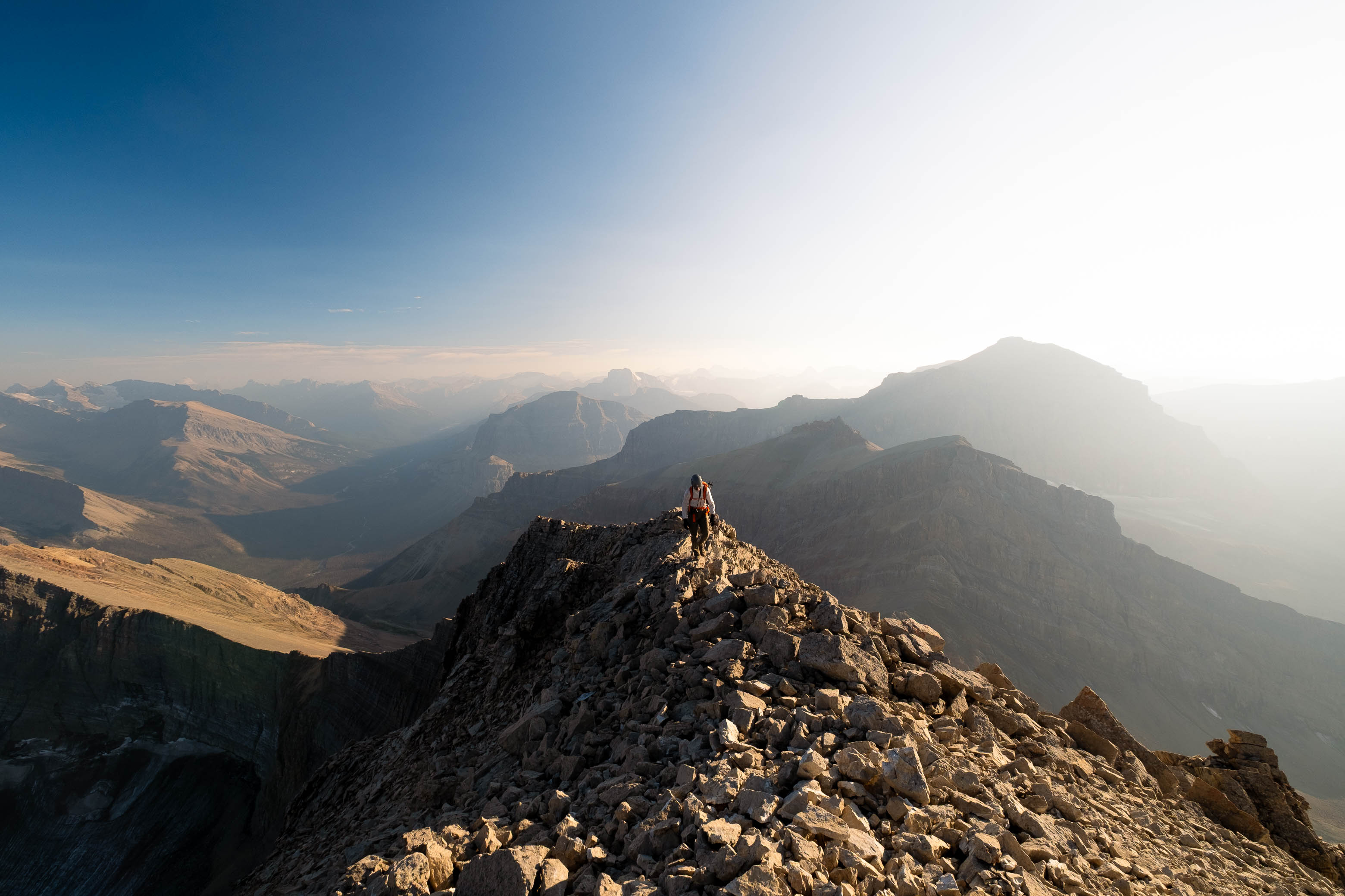
I have two words for the last big climb up this mountain - long and loose! I tried to lead the way up as much solid slab and as little loose scree as possible, but there was just no avoiding the treadmill entirely, and although we've been up much worse, it was obvious that my dad was struggling. Eventually we topped out onto slightly more solid rubble slopes, high above the col between Siffleur and an unnamed outlier to the west, and continued steeply up to the summit ridge. Hazey views back to the silhouetted forms of Loudon and Peskett continued to improve the higher we climbed and an incredible drop off the east side of the summit ridge kept us alert as we grunted up the final 100 meters to Siffleur's lofty apex.


Thanks to our significantly slowed pace, the sun was already starting to set as we reached the summit cairn - its warm golden rays cutting through the haze and casting long shadows across the valley. Not exactly the position I planned to be in, but how could I complain...It was absolutely stunning! I eagerly flipped through the register placed 30 years ago by Rick Collier, containing only three entries to date - 1924 F.A. by Topographical Survey, 1993 Rick Collier, 2023 Vern Dewit and Wietse Bijlsma - and while I just barely missed being the first one to crack it open since it was placed, being the fourth recorded ascent is still pretty darn cool and it was impossible to be upset considering the valuable beta I'd gained from Vern's report.


Time was most definitely ticking, but we'd worked hard for these views and with a cool breeze offering a welcome relief from the heat of the day we ended up spending almost an hour on our sunny summit perch before starting back down.


It was painful to watch my dad slowly limp down the summit ridge with the shadows rapidly growing as the sun set behind the mountain tops to the west. Our lengthy summit stay was a nice break from reality, but things were not looking good and I had a feeling we were in for a looong night! When it came time to descend the more solid, knee-jarring rubble slope we'd ascended from the col, I knew I had to find another option and was relieved to discover an incredible scree run by continuing down the summit ridge just a few meters south of our ascent line.

This worked brilliantly, and we spent the remainder of the descent seeking out these loose lines of scree, that we'd avoided like the plague just a few hours earlier, arriving back at our gear in the hanging valley just before we needed to pull out our headlamps.


I don't think I'll ever tire of watching the stars come out on a calm, clear night deep in the backcountry. Even with a bright, full moon, the stars put on quite a show, and as I lay there, gazing up at the millions of tiny bright lights in the sky, I was completely at peace with the fact that we hadn't made it back down to the Siffleur River that evening. What an incredible place to spend the night.
Photo Gallery


Disclaimer