Date: July 27, 2023
Location/Route Map: Assiniboine Provincial Park
Elevation: 2700, 2874, 2963 m
Elevation Gain: 1640 m (including an ascent of Cave Mountain on our way back to camp.
Distance: 24 km (from Lake Magog Campground)
Rating: Class 3/4 - Moderate/Difficult
Notes: Most of this traverse is easy scrambling, but one upper moderate/low difficult downclimb must be completed if traversing from Windy to Og's true summit. Alternatively, this downclimb can be avoided by ascending directly to Og via the valley to the south.
GPS Track: Download
After hiking in to Assiniboine from the Mount Shark trailhead, spontaneously deciding to complete The Cautley Traverse, rushing to bag all six peaks as darkness fell, and finally setting up camp and slipping into our sleeping bags well after 1 am, my dad and I were up again five hours later, eager to continue right where we left off! (Well, I can only speak for myself about the eager part...I think my dad was pretty happy right where he was. 😂) There were three peaks on the menu for our second day in the park - Windy Ridge, Og Mountain, and Cave Mountain. Windy Ridge and Cave Mountain are simple scree hikes which are ascended quite regularly, but Og Mountain is a little bit more of an obscure undertaking. The first highpoint on the west end of Og's lengthy summit ridge is labeled on maps as the official summit, but I didn't trust this considering that it's lower than all subsequent peaks along the ridge...(Personaly that doesn't sound very summit-like to me!) I came across Vern's trip report from his ascent of Og Mountain back in 2008, where he had the same suspicions I did and therefore continued along the ridge to the "fourth summit". While looking at my topo map, however, I noticed another "fifth summit", rising significantly higher than the fourth, about 1.4 km further east. If I was basing the summit strictly on elevation, then it only seemed logical that it was this peak that I would have to reach in order to claim true summit...It looked like I had some investigating in my hands, so that's exactly what I set out to do on an absolutely perfect morning in one of the most beautiful corners of the Rockies.


Poking our heads out of our tent to perfectly clear skies, we rushed to wiggle out of our sleeping bags and were leaving the campground within minutes, hiking down the trail towards the north shores of Lake Magog. A different trail leads more directly from the campground towards Og Pass, but personally I thought this minor detour was more than worth it to experience Mount Assiniboine's impressive, pyramidal form reflected perfectly in the calm morning waters.


After taking way too many pictures we were back on our merry way, soon passing the Assiniboine Lodge and making a wrong turn (a happy mistake), taking us to a magnificent viewpoint overlooking Lake Magog and the lush green valley that surrounds.

Retracing our steps back to the main trail, we continued north, following trail markers which kindly guided us towards Og Pass. A bright, morning sun warmed our chilled noses and rosy cheeks as we traveled through a broad expanse of open, alpine meadow, and it wasn't long before we were sitting down for some breakfast at the base of Og Mountain (you don't have to go right to the pass), enjoying yet another new angle of the one and only Matterhorn of the Canadian Rockies.


After finishing our "breakfast with a view", we started up switchbacks on Og's southwest, grassy slopes, following a good trail as it traversed around Og and led easily up to the col between Windy Ridge and Og's first (west) summit. From there, a short (under 10 minutes!) hike up scree already took us to our first summit of the day!

The vibrant valley directly below Windy Ridge's steep northeast face was definitely a highlight view for me, and I was already thinking about how neat it would be to come back and explore it someday...Always planning for the next adventure even when I haven't finished the one I'm on 😅. LOL.

After an enjoyable summit stay on this extremely high "bang for your buck" peak, we made a quick descent down the loose scree slopes back to the col to start up summit #2!

After a brief peek around the cairn for a register, we turned our attention to the long traverse ahead. We lost a bit of elevation from the first summit and promptly started towards the second. A noticeable scree trail has formed here, traversing around the right (south) side of the second summit and saves on unnecessary elevation gains. It should also be noted that the ridge cliffs out immediately after the second summit, so if you choose to ascend up n' over it you might just end up having to backtrack anyway.


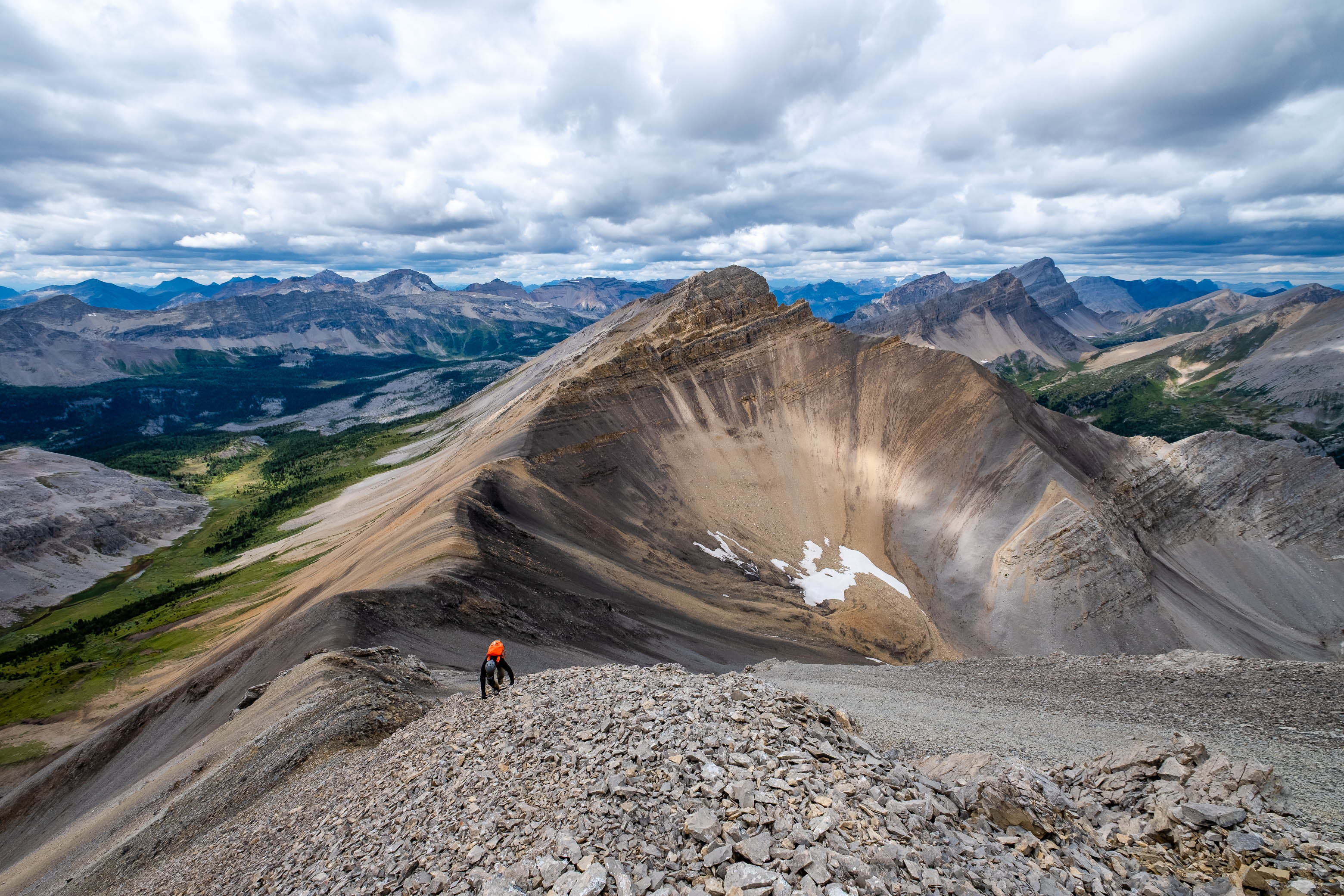
Once past the second summit, we easily continued on to the third, and this is where things started to get interesting! We found ourselves looking down some extremely steep and extremely loose gullies leading down to the col between summits three and four. There didn't appear to be any easier options at first glance, so I gingerly started down...but after a couple "test steps", I immediately decided I was not at all interested! Those things are a death trap! The only other possibility would be to descend right along the ridge crest, and I would have to agree with Vern's "low end of difficult" rating here. The exposure down Og's airy north face is definitely noticable, but if you carefully work your way down, focusing on one step at a time, it's really not as bad as it looks.


Having safely completed the crux, all that was left was another simple hike up scree, and we soon found ourselves atop Og's fourth (true?) summit. I was very surprised by the size of the summit cairn, but was unable to locate a register once again.

Looking towards the fifth summit from the fourth, it looked bloody far! No wonder Vern (and likely a good many others by the size of this cairn), were content to call it a day here. There's some serious elevation loss on route to the fifth, and one could easily argue that it deserves a separate title of its own! But since it hasn't been granted a name, and it is technically the highest point of the Og massif, it was the summit I'd set out to reach, and reach it is what I would do! - No matter the elevation loses and gains required...
UPDATE! After writing this report, I've learned that the "fifth summit" I describe in this report has actually been given an unofficial title - Bashan Peak - which I wholeheartedly agree with! (...even if it means that the register I left there is flawed 😕.) This means that the fourth summit is indeed the true summit of Og.


I thought we might be able to simply continue right down the ridge, but was immediately turned back by an incredibly loose and exposed cliff band that I wasn't about to tempt fate with. We retraced our steps back to the col between summits three and four, where we were then able to join a goat trail, bypassing the peak on its southern scree slopes. The sidehilling started out surprisingly pleasant, but would soon become downright nasty as the slope steepened and the trail was "washed away", replaced with crumbly, downsloping slabs and crazy loose gullies. Everything moved and this traverse went on for far too long. It was a relief to arrive back on the ridge, along with the solid footing it provided, and we both agreed that what we'd just completed was easily the "low-light" of the traverse.

The fifth summit looked bigger than ever, as we hiked over interesting shades of black and brown rock on our approach to the final climb. Time to regain all 200 m we just lost, plus extra!


The route to the summit is pretty basic stuff - follow the ridge...That's really all there is to it! Don't underestimate this final trudge though...The way might be obvious, but it sure is a slog! My dad was still in a sour mood from all the unpleasant sidehilling and seemed to be holding a grudge against any rock that moved - which was almost every rock between us and the summit 😂! It was a "two steps forward, one step back" kind of game for the bulk of the ascent and although at times it seemed like it never would, the slope did eventually relent and a short summit ridge led easily to a waiting summit cairn.

Unfortunately, a thick cloud cover had blown in as the day went on, making us wonder where the perfectly clear skies we'd had just a few hours earlier had gone. Even so, views down to Allenby Pass, 500 vertical meters directly below us, were absolutely incredible and there was no way I could even think about complaining, being two days in to a smoke-free trip that was forecast to be a complete smoke show! As expected, my GPS read 2963 m, about 100 m higher than the fourth summit. I placed a tiny film canister register in the small summit cairn, marking this as Og's True Summit, and somehow managed to waste away an entire hour before we were starting back down the ridge. I didn't mind though. We still had plenty of time left in the day and it was nice to enjoy the area at a more relaxed pace after rushing around like a mad man the previous evening!
The loose rock on the ascent ridge isn't exactly the kind that you get excited about going down, but it was still way more efficient than our fight against it on the way up, and we had soon returned to the low point between summits four and five.

Rather than reascend the fourth summit and reverse our entire ascent route, we descended directly down to Og Pass on the kind of rock that you do get excited about going down! A superb scree run on soft brown rock starts down the south slopes, and we had a blast flying down 200 m in just a few minutes, hitting vegetated slopes all too soon, and easily following them to the valley below. We noticed that our route got pretty bushy near the valley bottom and were able to avoid the bulk of the bushwhacking by angling right (skier's) and intersecting a narrow creekbed that broke through the thick, low-lying bush. (Note that this alternate descent is only possible "early season" due to a seasonal trail closure at Og Pass from the beginning of August to the end of September.)


Once we hit the valley bottom, we turned right on an obvious (but not heavily traveled) trail, passing a uniquely green coloured tarn on route to Og Pass and our final summit of the day!

Whether you're content to call it a day at the first summit, the fourth summit, or you're feeling ambitious and want to go all the way to the fifth, Og Mountain is definitely a worthwhile trip! The true summit may be a mystery, but I can definitely see an argument for both the fourth or the fifth getting the crown. All I can say is that if you do decide to go for the highest peak, make sure it's before August 1st so you can make use of the speedy alternative descent! Having to reascend the entire ridge on return would really suck...
Photo Gallery


Disclaimer