Date: November 9, 2022
Location/Route Map: Kananaskis (Highwood Pass)
Elevation: 2667 m
Elevation Gain: 700 m (500 m just to summit Pocaterra Ridge)
Distance: 9.5 km
Rating: Class 2
Avalanche Terrain Rating: Challenging
Notes: Skiing the backside chutes puts you in serious avalanche terrain. Only attempt with a stable snowpack and don't bring your favourite skis...
GPS Track: Download
While snowshoeing up Little Arethusa the previous day, I couldn't stop glancing across the highway, noticing a collection of ski tracks snaking their way down the snowy slopes on Pocaterra Ridge. While we did bring our skis along to the mountains, we originally had no intention of using them, scared to cause damage in the dicey, early season conditions. With that being said, my plan for the second day of our trip was to combine two "short" winter objectives on snowshoes, bagging Pocaterra Ridge in the morning, before descending almost all the way back to the highway, and tagging on Highwood Ridge to finish off the day...As it turned out, we had a pretty good vantage point up on Little Arethusa, and were also able to study Highwood Ridge's ascent route - Which was looking pretty risky, with that steep, north ridge already holding a lot of snow! With my initial plan not looking too promising, I spent the evening going back and forth in my head. "I wanna ski...but there are rocks...but I wanna ski!...but there are rocks...". I suppose the "I wanna ski" got the best of me 😉.

There wasn't a single cloud to be found in the blue bird sky as we set off from the Ptarmigan Cirque parking lot. It was another frigid -25 degree morning, and while I can't say our toes were stoked to be stuffed into ice cold pieces of plastic, our spirits were high as we started up an already well-trodden skin track with a warm morning sun shining brightly down on us.


Basically following the Pocaterra Cirque summer trail to a tee, we parrelled the highway for about 700 m before turning left into dense forest and traversing around the base of Highwood Ridge. We encountered a few more "downs" than we would have liked here, and after a little bit of survival skinning/skiing to wake us up (the dicey and icey state of the skin track added to the fun 😂), we were relieved to emerge to more open terrain below Highwood and Grizzly Ridge's steep north face.

We made quick work of the approach thanks to the solid skin track leading exactly where we needed it to, and soon arrived at the back of the cirque, where we could easily gain the south ridge of our objective. The imposing east face of Mount Pocaterra loomed over us as we followed a short series of switch-backs past treeline and were already enjoying some stunning wintery views as the slope eased off and we easily continued up the now open ridge towards the final steep summit push.


While the skin track did continue switch-backing it's way up the final steep slope, it also traversed over a few too many bare, rocky sections for our liking, and we chose to protect our expensive gear, throwing our skis on our backs, and bootpacking straight up the final 200 m to the summit ridge. Despite the freezing temps, we once again experienced the power of south facing slopes + a fierce sun, and found ourselves shedding layer after layer as we steeply climbed to the false summit.


The tracks stopped at the false summit, and it was up to us to pave the way along the short summit ridge. Although wind loaded, there wasn't enough snow to make us feel like we were doing anything sketchy and were soon standing on the summit with absolutely stunning views in every direction!


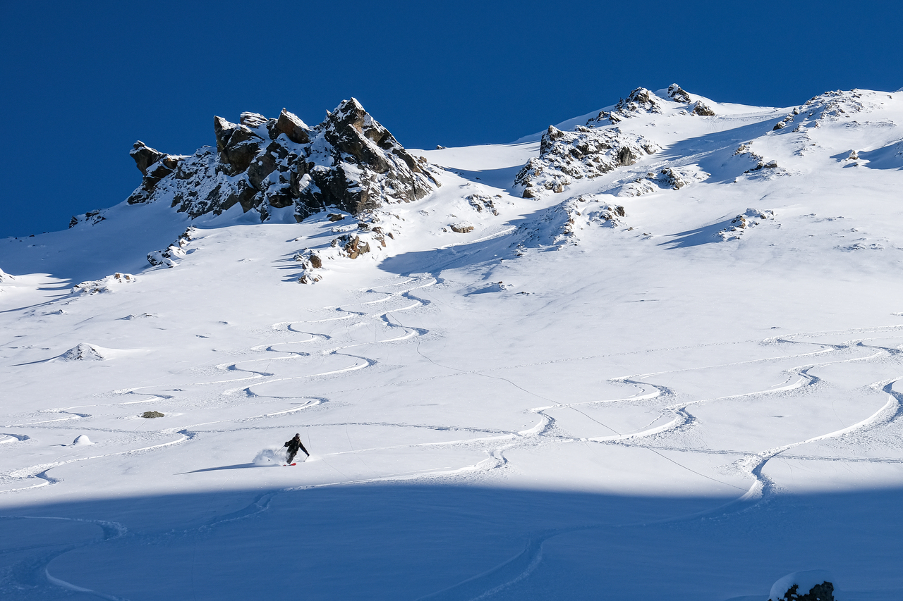
It's not often that we get lucky with weather this good in winter, and while we spent some time soaking in the incredible, cloudless summit views, a group of three splitboarders appeared on the false summit, transitioned to "ride mode" in no time, and promptly dropped down the steep chutes on the northwest face! Our original plan was to bootpack back along the summit ridge, and down the rock-protruding slope we ascended, before finally getting some turns in on the lower slopes where some more snow had collected, but as we watched the boarders cruise down the powder-filled chutes, our plans quickly grew in magnitude! Since there had only been one big dump of snow, followed by cold temps, there hadn't been a chance for weak layers to form in the snowpack quite yet. While this meant that an avalanche was less likely, it also meant that there was no solid base covering the rocks below! We considered our options, and ultimately ended up choosing "fun" 😉!


Now remember what I said about there being no solid base just yet? Well, that means that if you turn too hard in the wrong place, you slice right through the powder to the jagged "snow sharks" lurking just below. And that's exactly what I did...About halfway down the chute, I made a turn, heard a loud bang, and was sent off my feet, upside down before I could even register what happened! Somehow, miraculously, I managed to do one complete summersault, and land right back on my feet, skis attached and poles in hand, and while I may have been able to finish off the run as if nothing happened, my ski wasn't so lucky...Upon arriving at the valley bottom I hesitantly flipped it over to take a look at the damage and my heart sank as I discovered an absolutely MASSIVE core shot along its base 😭! So much for protecting my expensive gear!
Once descending into this hidden valley - sandwiched between the long northern ridges of Mount Pocaterra and Pocaterra Ridge - there really isn't any easy way out! You either follow the valley out over 5km to the north (leaving you about 7km away from your car...) or you skin up to the Mount Pocaterra/Pocaterra Ridge col (aka Little Highwood Pass), and then easily descend the side you came from. A hard decision, I know, but we ended up choosing the latter 😂.


A solid skin track from the splitboarders made our lives significantly easier, and it wasn't long before we gained the required 150 m to Pocaterra Ridge's west ridge, and were transitioning back to ski mode for a speedy descent down the south side bowl. We held off from putting skins back on until we reached Pocaterra Tarn (which is actually non-existent in winter), and even though the sun was now rapidly setting, we noticed another skin track heading up the powdery slopes below Grizzly Ridge's north face, and just couldn't resist a few more turns before calling it a day!


I really didn't want this day to end, but the sun had other plans and after relishing those last few weightless turns (this final lap was soooo worth it!!) it was finally time to leave this skier's paradise behind 😢.

Our headlamps illuminated the way for the last couple kilometers, and before we knew it, we were back at the open flats along the highway, finishing off a memorable day with a peaceful walk in the darkness.
I'm glad that I let the "I wanna ski" voice get the best of me...because this trip was an absolute hoot! I never thought of Pocaterra Ridge as a ski objective before seeing it from across the highway the previous day, but I'm sure happy I did, because I think skiing might just be the best mode of transportation for this one! There are so many options for making fresh turns and the bootpack was a breeze! (Especially when you compare it to something like Chesmill...) It was amazing to pick up where we left off last May (with a snowshoe and ski ascent under clear, blue skies), and I really hope the trend continues and we get a few more days like this, and a lot less of that whiteout crap that we had last year 😝!
Photo Gallery


Disclaimer