Date: November 8, 2022
Location/Route Map: Kananaskis (Highwood Pass)
Elevation: 2761 m
Elevation Gain: 600 m
Distance: 4 km
Rating: Class 2/3
Avalanche Terrain Rating: Challenging
Notes: Completing this ascent in winter significantly increases its difficulty. Extra caution is required while traversing the narrow and sometimes exposed summit ridge.
GPS Track: Download
I hadn't been back to the mountains since my sunny, warm, and dry ascent of The Wedge with Taz, Braydan, and Avery back in October...and let me tell you, the Rockies were a completely different world! Having received a major dump of snow over the last couple of weeks, everything was already covered in a bright layer of white, and the -25 degree temps were just a little bit of a shock! There was only about one thing that remained the same from my last visit, and that was the beautiful sunny skies, which (as we learned last year) can be quite the rarity in winter! Eager to make the most of the beautiful weather (aside from those gnarly temps!), we headed up to Highwood Pass (only open until December 1st) to experience this beautiful area with its winter coat before it closes off for the season!

I don't know about you, but Nugara's suggestion of parking at the Ptarmigan Cirque parking lot and trekking 1.4 km south along the highway to reach the summer trail didn't entice me all that much...But lucky for me (and you!), a different option exists, and some previous tracks, along with Vern's trip report, prompted us to take a more direct line, ascending an open gully directly across the highway instead :).

We found an old track entering the trees, and easily followed it as it switch-backed its way through the dense forest, eventually emerging to the open gully. The sun was shining brightly, and the views back across the highway continued to get better and better as we climbed, but as beautiful as the weather appeared, it was mighty cold, and within 20 minutes of setting out into this arctic landscape we already had to stop and stick some hand warmers in my dad's boots, whose feet were already going numb!

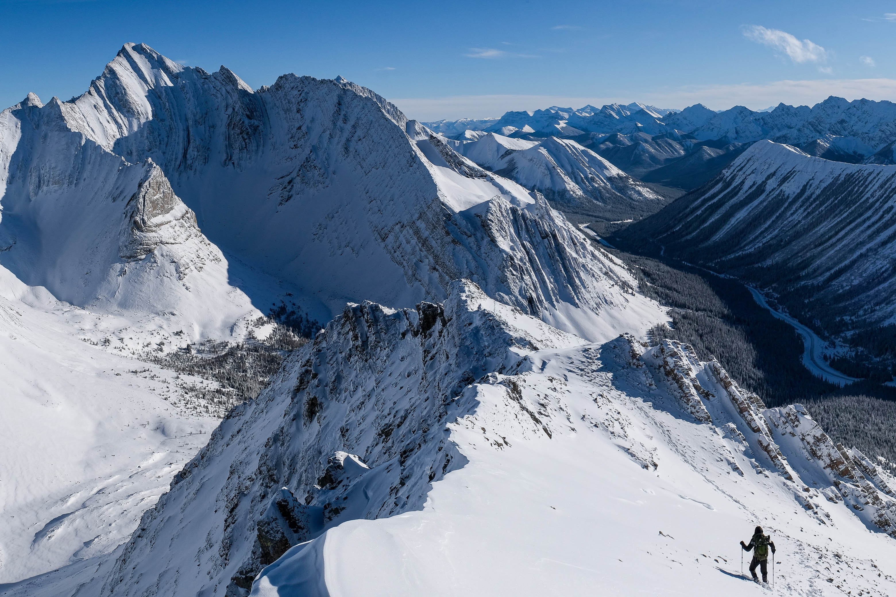
We soon reached the top of the gully, and began traversing below Little Arethusa's steep, western slopes. While Vern simply ascended straight up to the ridge here, those steep, slick slopes were unsuccessful at gaining my interest, and we decided to make our lives easier by adding a little bit of extra distance to our day in order to reach the (more pleasant) south ridge.


As we grinded up the southern slopes, with the sun beating down, that big ball of fire in the sky started working wonders, and we were shocked to find ourselves suddenly overheating and having to shed layer after layer as we made our way up to the summit ridge. It seriously felt like spring! Luckily the snow cover was still pretty sparse on this slope, so avalanches weren't of concern for us, but this slope should still be treated with respect! There are definitely sections that are steep enough to slide in the right (or should I say wrong!) conditions.

Eventually we reached the summit ridge, and with a steep drop-off down the east face, this little peak is definitely more interesting than the highway view suggests! We swapped out our snowshoes for microspikes and began our traverse just below the ridge, to climber's left, but a steep, snow-loaded slope soon forced us back up to the crest. After traversing a short, exposed step, the ridge eased off again and we continued up, making sure to keep a safe distance from the big drop to our right, unsure what lay beneath the snow cover.

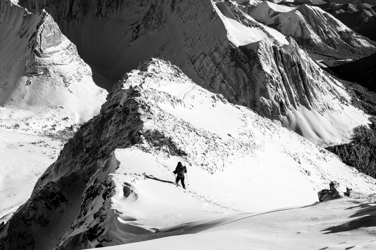
When we reached the final short climb to the summit, we decided that the ridge crest looked a little bit too risky for our liking and descended a short ways to our left, before ascending the steep, rock-protruding slopes directly below the summit. This route was only made possible thanks to favourable conditions at the time of our ascent, but if this slope had a little bit more snow on it, it would've turned into some serious avalanche terrain with a nasty runout! To be honest, I have no idea what the best course of action would be if this slope was heavily snow-loaded...Probably just go home 😂!


I was ready to celebrate as I reached what I thought would be the summit, only to realize that an ever-so-slightly higher point lay a short, narrow, exposed and completely snow-covered ridgewalk away! With a sheer drop on one side, and a steep, snowy chute on the other (both of which dropped hundreds of meters down to the valley below 😬!), this finale was definitely the sketchiest part of the climb. My dad wisely chose to remain on the safety of the "first peak" while I removed the snow basket from one of my poles and probbed the ridge as I carefully inched my way to the summit.

Views were absolutely phenominal, as one would expect on a blue bird day from a peak as strategically placed as this, and after taking way too many pictures from my tiny summit perch, I carefully retraced my steps back to the more spacious "false summit"...where I proceeded to take even more pictures! 😂


After a cold, but beautiful summit stay, we left a register at the cairn on the slightly lower summit and began retracing our steps down the mountain.

Descending the summit ridge was much easier with a "trail" to follow and it wasn't long before we were having a blast plunge-stepping/sliding our way back down the south slopes, reaching treeline in no time and easily continuing down to the highway.


What an incredible way to kick off the season! After experiencing way too many bad weather days last winter, any day that isn't a whiteout feels so special! We couldn't have asked for better weather for our first ever snowy adventure up at Highwood Pass (well I guess a little warmer would have been nice...), and the winter stoke is officially high!!
Now snowshoeing is fun and all...and we weren't planning on bringing out the skis this early in the season...but I may have noticed some ski tracks across the highway on Pocaterra Ridge...Any guesses what we'll be doing tomorrow?? 😂
Photo Gallery


Disclaimer