Date: Feburary 7, 2024
Location/Route Map: Icefields Parkway (South)
Elevation: 2750 m
Elevation Gain: 1300 m (including 2 upper laps)
Distance: 12 km
Rating: Class 2 - Easy
Notes: This is one of those peaks that was made to be skied. Wait for a clear day and a solid snowpack and you will not be disappointed!
GPS Track: Download
Tuesday's stormy weather found my dad and I lapping Observation's lower SW slopes, and while the ski conditions were great fun, the whiteout that we found ourselves in for most of the day left something to be desired. While the forcast wasn't looking the most promising for the following day, the sky was slowly starting to clear as we hunkered down for the night and I fell asleep hoping the weather would hold up enough for us to go for a summit the next day. My wish came true, and Wednesday morning dawned crisp and clear, with not a cloud in the sky! To say I was a little bit excited would be a major understatement! I immediately had my nose deep in my phone's topo map, in search of a ski objective that would benefit from this major improvement in weather, and the skier's summit of OXO/Puzzle Peak (aka Watermelon Ridge) - the furthest peak on the southeastern end of the impressive OXO Peak "wedge" - immediately stood out thanks to its ramp-like ascent slopes (perfect for a ski descent), its SW aspect (same aspect as Observation where we found great turns the previous day), and its prime location, smack dab in the middle of the Mosquito Creek valley (a beautiful area I'd never visited before)!

We got lucky with a freshly plowed Icefields Parkway and were easily able to park on the wide shoulder where we noticed some ski tracks entering - and exiting - the forest. (Note that this route is not the same as the summer route up Mosquito Creek and starts about 1 km north of the Mosquito Campground turn-off.) It was an absolutely perfect morning as we geared up for the day, with beautiful sunlight just starting to illuminate Bow Peak's snowy east face across the highway, and I have to admit, I was a little bit disappointed we already had to leave these views behind as we started up into the dense forest.


Luckily we had a fresh skin track paving the way for us (probably no more than a day or two old) and made short work of the initial "steep" section, before the slope flattened out and we continued around the base of Dolomite Shoulder's steep SE slopes. Depending on where you round the shoulder you might (like us) find yourself at the edge of a steeply walled drainage, but don't trouble yourself with crossing it! Instead, backtrack along the edge of the drainage towards Dolomite Shoulder, where it becomes much less "aggressive" and easier to cross.

Once across this drainage, we easily continued up rolling, forested terrain, towards the base of OXO/Puzzle Peak's SE ramp. We were still following a skin track at this point, but when it eventually split in two different directions (neither of which made much sense for us) we started breaking our own trail, stumbling upon a narrow drainage that conveniently broke through the last remaining trees and spit us out right at the base of our ascent slope. Nice!


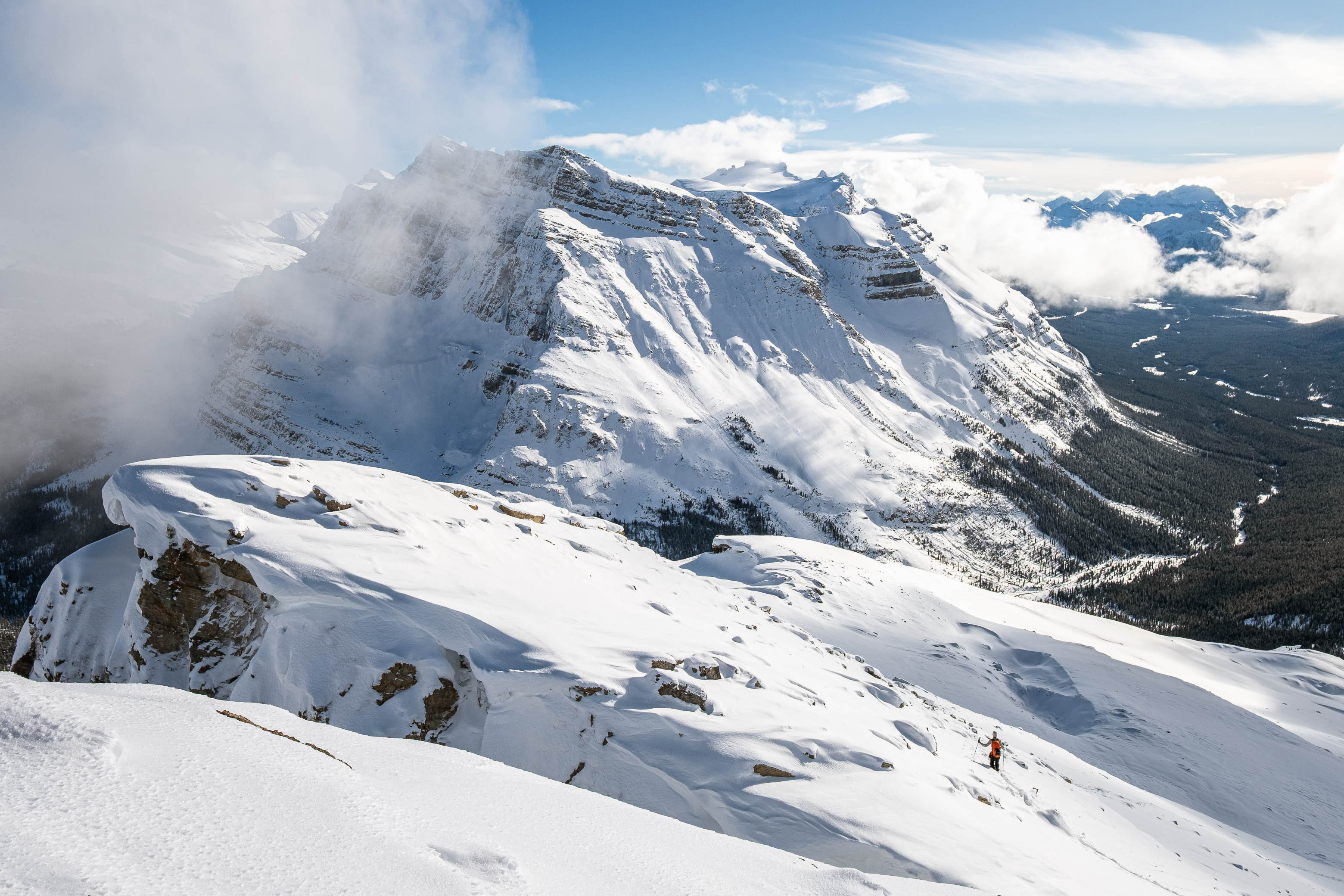
The views opened up spectacularly behind us as we broke into the alpine, with the distant Lake Louise group rising over a partial inversion in the valley, Noseeum's west face towering across Mosquito Creek, and a deep blue sky overhead! This was shaping out to be one of those magical winter days you don't forget!


As we started towards the ramp, we once again joined with an old skin track (I guess we could've followed it afterall!), but it soon came to a halt at the top of a minor roll and we were left to break trail once again. The views kept getting better and better as we set switchbacks up the ramp and we were soon stripping down to just our base layers in the calm, windless conditions, as a blinding sun cast warm rays down on us. I could've almost been fooled that it was Spring as I powered my way up the mountain, but the snowpack gave away what time of year it really was and the amount protruding boulders and undulations in the slope already told me we'd have to be careful dodging sharks on our ride down!


The ramp steepens considerably for the final 150 vertical meters to the summit, and we chose to branch off to more ridge-like terrain to climber's right, rather than tackle the steep slopes directly below the summit. We started by skinning up the ridge, but were almost immediately forced to bootpack as we found ourselves breaking through to rocks under the ever-thinning snowpack.


At this point my dad threw out the idea of forgoing the summit and spending the extra time lapping the lower ramp instead - since it was now obvious we wouldn't be getting any turns on the upper mountain - but with the slow start to the winter I was itching to bag a summit (even if it was an unofficial one!), and led the awkward march up the slippery, snow-covered scree slopes in ski boots, determined to tag the summit and get a second lap in! As we made our way up the final climb, we noticed another party reach the top of our skin track, break trail a little bit further up the ramp (not the ridge) and transition for what appeared to be a stellar ride back down. I honestly expected to meet them later in the day, but they must have headed out after the one lap, because we never saw them again. (I later found out that this was once again Marcus Baranow - the author of the Confessions of a Ski Bum guidebooks - who I had also just narrowly missed meeting the previous day at Bow Summit! What are the odds!)


The final few meters to the summit were the worst, with my leg unexpectedly "disappearing" into the mountain multiple times as the scree transitioned to larger "boulders" and I inadvertently stepped into the big, hidden gaps that were lurking under a thin layer of snow. But in a few short moments this would all be forgotten, and we topped out on the summit to absolutely stunning views in all directions, with an impressive geological display up the connecting ridge to OXO Peak (its impressive NE face dropping an airy 700 m directly to the valley bottom!), beautiful wintery views towards 11,000ers like Willingdon and Crown down the remote valleys to the north, and incredible cotton candy clouds appearing out of nowhere and putting on quite the show back to the south! All this and more with not a breath of wind!


I could've easily spent over an hour up on our summit perch, relaxing and soaking in the amazing winter scenery, but this summit stay was cut uncharacteristicly short for me, eager to still squeeze in a couple laps on the lower ramp before we ran out of daylight.

The descent back to our skis went quickly, and we were soon following the other group's short extension of our skin track, before transitioning for what was indeed an absolutely stellar run! 350 m of boot-top powder combined with the awe-inspiring winter scenery easily makes this one of my top 3 ski ascents/descents to date, and after cruising to the bottom of the ramp there was absolutely no question that we were heading back up for more!


The final hints of sunlight were just barely kissing the mountain tops as we finished off our second lap and we extended our run slightly by making use of the narrow drainage gully we'd used on ascent, before being forced to switch back to skins for the hike back out.


When we arrived at the final slope down to the highway, the forest had become completely engulfed by darkness and we packed up the skins and pulled out our headlamps for some of the most intense survival skiing I've experienced! 😂 Luckily we both managed to make it down in one piece, but our day wasn't done yet thanks to the long, monotonous drive back to Edmonton that still awaited us.


I can't recommend this tour enough! The approach isn't overly long or complicated, the skiable terrain is phenomenal, and the views on a clear day are bound to blow you away! It was great to bag a "summit" on skis again after what's felt like a long drought since December, and this unforgettable day provided me with something that's been missing from my life these past few months. Boy is it good to be back!
Photo Gallery


Disclaimer