Date: October 18, 2022
Location/Route Map:Kananaskis Valley Elevation: 2667 m
Elevation Gain: 1150 m
Distance: 7.7 km
Rating: Class 3/4 - Moderate/Difficult
Notes: The short, exposed downclimb along the summit ridge is awarded a difficult rating by Kane, but I'd argue it's actually more in the moderate realm.
GPS Track:Download
The Wedge has been on the to-do list for quite a while...Like its name suggests, this impressive peak juts out like a big wedge, and can't be missed as you drive south (past Kananaskis Village), along Highway 40. I stare up at this mountain every time we drive through Kananaskis, and it was just a matter of time before I finally stood on its summit! After taking Braydan and Taz on their first ever scramble the week prior, Avery was also able to get the day off this week, and the four of us were off for the mountains for round two!...Well, after first turning around 5 minutes outside of Edmonton as Braydan anxiously rustled around in the dark car, realizing he forgot his phone 😂.
The Wedge Route Map (see link in desciption - or click here - for interactive version).
Starting out from the Wedge Pond parking lot, we passed the gate on the far-south end, before turning right, down a wide, gravel trail. After following this trail for a mere 70 m, we then took a left, and started up a far less travelled trail through the forest. A few hundred meters later, we somehow lost said trail, finding ourselves in a bushy situation and wondering what went wrong...😂 Luckily the bush was easy to navigate and it wasn't long before we came across a stream, rediscovering the trail on the opposite side.
This newly discovered trail was an absolute breeze to follow, and we were soon climbing out of the trees and enjoying some beautiful views back down the Kananaskis Valley as we neared The Wedge's lower north ridge.
Kidd South and Mount Kidd, tower over the flat, expansive valley below, as we gain our objective's lower north ridge. Lots of talk of climbing Mount Kidd after today!
After taking a short break to catch our breath and enjoy the view, we easily continued up the ridge, with our objective looming straight ahead. Upon reaching the base of The Wedge's daunting north face, we traversed around to the eastern slopes until we found some terrain that didn't require ropes, and started up the steep, rubble-strewn "steps" leading to the summit ridge, 200 meters above.
The Wedge's imposing north face rises ahead as we start up the ridge.
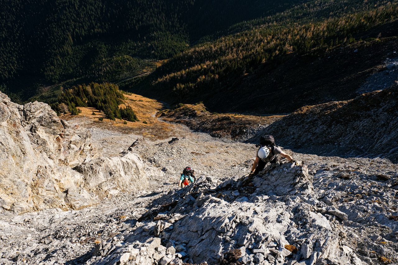
Scrambling time :)!
Solid rock ribs between loose gullies made for some fun scrambling, but even these were littered with loose rock and we were very happy to have our helmets, as we carefully picked our way up the face. Eventually the angle of the slope eased off and we found a trail weaving its way up the rubble, easily leading us right up to the summit ridge.
Looking ahead. We chose our route based on whatever looked the most solid - in this case, the rock rib center-right.
Taz and Braydan start up the rock rib.
The terrain eases off as we near the summit ridge.
We were a little bit dissapointed to discover a thick layer of smoke obscuring many of the views to the SW when we arrived at the top of the face, but focused our attention on the very impressive summit ridge instead, easily walking up to the false summit before it was time to tackle the exposed crux downclimb.
The true summit looks pretty darn impressive from the false summit!
While Kane rates this step as difficult (and care is required), I honestly didn't find this step to be all that bad, and would agree with others who suggest that this short section sits closer to being moderate ¯\_(ツ)_/¯.
The crew takes on the short, but very exposed, crux downclimb.
The drop to the west was absolutely spectacular as we continued along the ridge, but we didn't face any real challenges after the crux and were soon relaxing on the summit, on an completely windless October afternoon. It would've been a perfect day if it weren't for the smoke, but it's hard to complain when you're wearing a t-shirt on top of a mountain at this time of year!
Looking back down the ridge, to the false summit. Many familiar Kananaskis peaks are visible, including: The Tower, Lillian, Kidd South, Bogart, Kidd, Wind, Allan, Collembola, Skogan, Lorette, Wasootch, and Kananaskis (L to R).
Taz continues down the south ridge with Fischer, "Ripsaw", Denny and Opal Ridge making up the backdrop.
Relaxing on the summit on a beautiful October afternoon.
An impressive, unnamed tower juts out from The Wedge's lower south ridge.
After a short exploration further down the south ridge to get a better view of an impressive tower, we started retracing our steps back down the mountain.
Climbing back up to the summit after briefly exploring further down the south ridge.
Re-ascending the crux definitely felt easier than downclimbing it had and we were soon making our slow, methodical descent of the NE face, taking turns downclimbing each step to midigate rockfall hazard as much as possible.
Looking back at The Wedge's aesthetic summit block.
Upclimbing is always easier than down-climbing!
Looking across the near-vertical north face!
Taking turns down-climbing the steep, loose NE face.
The remainder of the descent went without difficulty, and we easily followed the trail all the way back to the parking lot, no bushwhacking required! 😉
Hiking back down the ridge in the warm, late-afternoon sunlight. Days are getting shorter!
Galatea, Fortress Ridge, and The Tower rise in the haze, beyond a silhouette of tree tops.
Following the lower trail back to the Wedge Pond.
And that concludes another memorable day in the mountains! I'm so thankful that the weather held up so beautifully, allowing us this last scramble before the snow begins to dump. It was so much fun to scramble with this amazing team, and I can't wait for more unforgettable adventures (on skis!!) this winter! 🙂
Photo Gallery
Leaving the wide gravel trail and starting up The Wedge on a narrow path entering the forest. (Photo taken on return.)
We found ourselves bushwhacking after losing the trail 350 meters later...
We angled left, up through the bush, and eventually came across a stream, rediscovering the trail on the opposite side!
This newly discovered trail was an absolute breeze to follow, and we were soon gaining elevation high above the creek, with The Wedge and Limestone Ridge rising impressively on our right.
Taz and Avery grind their way up the final steep section before we reach the ridge.
Beautiful views across to Kidd South and Mount Kidd, towering over the flat, expansive valley below. Lots of talk of climbing Mount Kidd after today!
The calm, reflective waters of Wedge Pond look far away now!
Nice spot for a break :).
The Wedge's imposing north face rises ahead as we start up the ridge.
Traversing around to the eastern slopes until we find some terrain that doesn't require ropes!
Scrambling time :)!
Starting up the steep, rubble-strewn "steps" leading up The Wedge's eastern slopes.
We're just a bunch of goofs. 😂 Photo credit: Avery
Looking ahead. We chose our route based on whatever looked the most solid - in this case, the rock rib center-right.
Taz reaches the top of the rib.
Comprehensive view back down. This is a good place for a helmet...
...especially with this guy around 😂. Braydan scrambles up, sending hundreds of rocks down as he goes! (Don't worry Braydan, we love scrambling with you anyways 🙂)
Avery making it look easy on her first scramble ever! She even had the extra task of dodging Braydan's rocks along the way!
Scrambling up some loose terrain above the rock-rib section.
Taz tries out a different route.
The angle of the slope eased off as we angled right, onto a broad ridge. Here we even found a bit of a trail, weaving its way up the rubble, and easily leading right up to the summit ridge. Note how Avery's moved up in the group, no longer in Braydan's fire zone 😂.
Not far to the ridge!
Looking up to the false summit, as we top out on the summit ridge. The Wedge's true summit is also visible, peeking out to the left.
The true summit looks pretty darn impressive from the false summit!
The crew takes on the short, but very exposed, crux downclimb.
Braydan throws a thumbs up despite being terrified and not knowing how to get down the next step. 😂
Continuing along the ridge to the true summit. While the drop to the west is spectacular, the ridge is wide enough that the remainder of the ascent goes without difficulties.
Relaxing on the summit on a beautiful October afternoon.
Looking back down the ridge, to the false summit. Many familiar Kananaskis peaks are visible, including: The Tower, Lillian, Kidd South, Bogart, Kidd, Wind, Allan, Collembola, Skogan, Lorette, Wasootch, and Kananaskis (L to R).
Smokey, smokey, smokey! Visible from left to right are silhouettes of Evan-Thomas East, Mount Denny, Opal Ridge North Peak, Mount Inflexible, and finally Mount James Walker.
Woah! Those are some funky clouds.
Keeping the summit meal tradition going! This time Chef Taz cooks up some Summit Pad Thai!
Kidd South Peak and Mount Kidd impress across the valley, with Mount Bogart rising between them!
It's a long way down!
Mount Denny looks incredible, even in the smoke! That's a mountain that's been on my list for a little while now...
Summit selfie! We definitely got this one first try...😂
I was honestly surprised not to find a register on this one...But don't worry, there's one now :)!
Taz continues down the south ridge with Fischer, "Ripsaw", Denny and Opal Ridge making up the backdrop.
Taz explores down the south ridge for a short distance.
After hyping up how cool it was, the rest of us decided to follow him ¯\_(ツ)_/¯.
Venturing farther down the ridge. Photo credit: Mr. Taz
The highlight of our short extension was a clear view of this impressive, unnamed tower, far down The Wedge's south ridge.
Looking back up to the summit, with Avery perched on the ridge.
A closer look at the gnarly looking tower! Wonder if anyone's climbed it??
Heading back up to the summit.
Old Baldy, McDougall, "Purgatory", "Perdition" and Fisher rise over Mackay Hills to the east (L to R).
Braydan and Avery start down from the summit block.
Looking back at The Wedge's aesthetic summit block.
Upclimbing is always easier than downclimbing :)!
An overhead look down the crux.
Final view back to the summit.
Walking the ridge.
It was neat to look down to Limestone Mountain and Limestone Ridge. I remember scrambling up both back in April (as one of my first scrambles of the year), gazing up to The Wedge's stunning north face. Now I stand atop that face, looking back, on what could likely be my last scramble of the year! Funny how these "full-circle" moments happen without any planning.
Into the shadows. Avery, Taz, and Braydan start back down the trail which leads down the upper half of the eastern slopes.
Looking across the near-vertical north face!
Soon the easy scree trail came to an end, and it was time for some downclimbing!
Avery starts her descent.
Fisher would make for a looong day!
Braydan carefully makes his way down the rock-rib section.
Taz comes down next. Note Avery patiently waiting in the upper-right corner of the frame. We took turns downclimbing this section to mitigate rockfall hazard.
Looking down the final short section before we traverse back to the lower, north ridge.
Braydan's got that butt-scrambling technique mastered 😂.
Looking good team :)!
Avery down-climbs the final section, as we reach the bottom of the eastern face.
Back on easy ground.
Hiking back down the ridge in the warm, late-afternoon sunlight. Days are getting shorter!
Galatea, Fortress Ridge, and The Tower rise in the haze, beyond a silhouette of tree tops.
Ray of sun.
Following the lower trail back to the Wedge Pond.
"Anyone want to go for a swim?...OH! Nevermind, there's a cigarette in there!" 😝