Date: July 29, 2023
Location/Route Map: Assiniboine Provincal Park
Elevation: 2810 m
Elevation Gain: 900 m
Distance: 30 km (from Lake Magog Campground to summit and exit to Mount Shark Trailhead)
Rating: Class 4 - Difficult
Notes: Naiset "Peak" and Naiset "Point" are two different peaks - This report is for the "Peak", which is a very loose ascent with high objective hazard!
GPS Track: Download
After bagging 13 summits in 3 days while camping at Lake Magog in the mind-blowingly beautiful Assiniboine Provincal Park, there was one final peak I had my sights on standing atop (even if I wasn't completely sure what peak that was...) on our fourth and final day, before making the long trek back out to the Mount Shark Trailhead. Naiset Point was one of the many peaks that caught my attention while compiling my peakbagging master plan for the Assiniboine area, but a quick search of the www was unable to provide me with the beta I was looking for. Other than a brief description on bivouac.com (I'm not a paid member unfortunately ☹️), I didn't have any ascent/route information until recently picking up a copy of David Jones' "Rockies South" guide. Immediately flipping to the Assiniboine section, I discovered "Naiset Peak" (not Point!) mentioned, with various routes leading to its apex, one of which was reportedly only class 2 (easy scramble)! Based on how simple the short route description was, I assumed this would be a gimme peak that we could easily tag on our way out. I snapped a picture of the page for future reference, and didn't give it much more thought. What I didn't initially realize was that Naiset "Peak" and "Point" are not actually the same thing, and based on the "class 2" rating for Naiset "Peak" in the guide book, it appears I'm not the only one who's made this mistake...


As we continued towards Gog Lake, the fog started to dissipate and we witnessed an absolutely stunning view of Mount Assiniboine and company lit up in the morning sun under a perfectly clear blue sky! We stopped for a few minutes just to soak it all in. We'd gotten so unbelievably lucky with weather on this trip and who knows how long it'll be until I'm back at this magical place.

Shortly thereafter we arrived at Gog Lake's lush, mossy shores which was a brand new sight to me, having walked past it in pitch darkness three days prior...It's crazy how concentrated this small area is with these beautiful gems. It seems like after every few kilometers you turn a corner and come across a pristine alpine lake or jaw-dropping viewpoint! This truly is one of the most beautiful places (along with Lake O'Hara earlier this month) that I've been lucky enough to experience.


We left the main trail here, and followed a narrow path along the east side of the lake. We hoped we would be able to easily follow it right around the lake, but the path quickly came to an end at a small waterfall and a few meters further the shore cliffed out on us. Luckily we were able to easily scramble up to the treed plateau above the lake (to our left) and continued through the forest, soon emerging at the massive scree basin between Naiset Point and The Towers.

It was only as we started sweating our way up the basin with a fierce morning sun already baking our entire ascent route, that I began to seriously question which mountain we were climbing...For the whole trip I was completely convinced that we would be ascending Naiset "Point" (the outcropping at the far north end of the ridge extending perpendicular to the connecting ridge between The Towers and Terrapin Mountain). It wasn't until the previous night, however, now having completed all of the other objectives I had planned, that I took some time to re-read the route description (this time more in depth!) and realized that Naiset "Peak" (as described in the book) is not the outcropping at the end of the ridge, but instead the higher point directly between The Towers and Terrapin, about one kilometer south of the Point! This didn't initially faze me - so we're climbing a different mountain than I originally thought, no biggie 🤷♂️ - but now as I stood on location, trying to match the route-description to my surroundings, the confusion started to set in...
"From Gog Lake, ascend towards the head of the basin formed by the objective and The Towers, then climb the east slopes over scree and easy rocks to the top." - David Jones' Rockies South Guide
I looked up Naiset Point's eastern scree slopes as we passed under them and they seemed to match this description pretty well. The peak, however, not so much...


We sat down to have some breakfast and I spent some time going through my camera, hoping to find some pictures that I took from the top of The Towers a few days ago that might give me a better idea of what the route up Naiset Peak looked like...And let me tell you, it didn't look too good! The only possible route I could pick out started up steep scree slopes after reaching the col between the objective and The Towers, but soon hit what appeared to be an impassable cliff band followed by a collection of scary-looking pinnacles, littered with loose rock. There was no way that could be referred to as "scree and easy rocks"...right?
I sat there for a few minutes, completely conflicted, re-reading the route description over and over, thinking I might discover some magical piece of information in that brief collection of words that I somehow overlooked the past 20 times I read them.
Nope.
I quickly got fed up with all the sitting around and indecisiveness and just said "screw it", got up, and continued past Naiset Point and towards the steep scree slopes leading to the col between The Towers and Naiset Peak. My gut told me that the route description was definitely for Naiset Point (not Peak) and if I wanted the best chance at making a summit I should immediately turn right and head up those scree slopes...But after looking at my pictures from The Towers I had become completely intrigued with the much more impressive and gnarly-looking Naiset Peak, and couldn't help but wonder if some sneaky route somehow led to its summit...And there was only one way to find out!

We started up the steep slopes directly in front of us, which consisted of loose sections of treadmill scree followed by some hard packed dirt, littered with bits of that loose scree 😝 - slip here and you'll get some nasty mountain road rash! While this is definitely not the type of terrain that I'd consider a joy to ascend, this would turn out to be one of the better parts of our climb to the col...
Luckily this slope didn't go on forever, and the grade soon eased off as we reached a bit of a raised "ridge" if you will, angling from left to right across the slope and towards a break in the broken cliffs above. We enjoyed some solid-ish rock underfoot, and even a brief patch of shade from the wall rising to our left as we climbed towards the cliff band, but unfortunately this was short-lived and we were soon grinding our way up a treadmill once again, breaching the cliffs on the far right side (climber's).


Once above the cliffs, the terrain immediately flattened out as we entered the upper bowl. We were surprised to find ourselves in what appeared to be a moraine of sorts and wondered how long ago glacial ice filled the rubbly bowl in which we now stood. After hiking a few meters further up the bowl, we realized it couldn't have been that long ago, because the glacier was still there!! Filling the upper left half of the bowl, lay a rapidly receding glacier, littered with bits of rubble and gushing water through hundreds of narrow channels, snaking their way down the glacier's glistening surface in the intense late-morning sun.


Looking up the remainder of our ascent route, the col was finally starting to look closer and all we had to do was scramble up one final scree slope to reach it! (If only it could be that easy...) On rubble immediately right of the glacier, we started up terrain typical to this ascent - steep, loose, but manageable - and just as the col seemed to be within our grasp, things started to get a little bit more interesting...The higher we climbed, the steeper and looser the slope became, and it came to a point where with each step a significant amount of rocks (not just around where we were stepping, but also multiple meters above!) would shift. The glacier had left its surroundings in some real rough shape, and it's obvious that very few (if any!) feet have ever touched this rubble! What didn't help, was the distinct sound of rockfall from the glacier that accompanied us as we climbed. Luckily we were safely out of the glacier's "fire-zone", but this still prompted quite a few nervous glances to the cliffs above.


The most nerve-wracking section was, of course, immediately before reaching the col, when a disturbingly large section of rubble started sliding beneath my feet! I quickly ran/scrambled my way out of the slide zone and looked back to watch rocks continue to "avalanche" their way down the slope on which I had just stood, leaving a bare line of hard packed dirt in their wake.
We breathed a sigh of relief as we both topped out safely at the col, but this was no time to celebrate! We would still have to make our way back down that hell of a slope, not to mention what still lay ahead of us...

Naiset Peak's summit block looked no less daunting than it did from the top of The Towers a few days prior (if anything it looked even more scary!) and after what we'd just been though, this mountain was really starting to loose its charm. Nevertheless, I'm a determined peak-bagger at heart and although this one truly looked like it was out of our reach, I wasn't about to give up until I absolutely had to!
My dad reluctantly followed me as I continued up another slope of steep and loose scree towards the formidable cliffs above. Once we neared their base, we started traversing below them, inspecting them for any possible weaknesses. I held my breath as we came up to the ridge connecting Naiset to Terrapin, having now traversed below the whole cliff band without any obvious routes jumping out at us, and desperately hoped a route would present itself around the corner...But what we found instead, was a terrifying wall of absolutely vertical rock with no scrambling possibilities whatsoever. Well, if it wasn't obvious already, I can confidently say that the Class 2 route description in Rockies South is most definitely not for this peak!


As we started the traverse back along the cliff band, we went to check out a couple narrow chimneys that I'd picked out on our first pass-by. They sure didn't look the most inviting, but they were kind of our only option at this point! The first chimney was quickly deemed a no go, but the second one looked promising! I started up a short moderate step to a small ledge, at which point the chimney narrows dramatically. I tried squeezing though, but that was simply not possible with my 40L overnight bag on. (Not that it would've been possible with any size bag to be honest!) I then resorted to taking my bag off and tried stuffing it up the chimney in front of me, but this was even more awkward, and I quickly got stuck and found myself having to retreat once again. The only option that remained was ditching our packs and continuing to the summit without them. The problem with this, however, was that there really wasn't any secure spot to stash them on the steep, loose mountainside!...Luckily, after downclimbing back out of the chimney, we were able to lift our backpacks onto a couple solid ledges in the cliffs, and headed back up for take two!


Now, with only our cameras strapped around our necks, we were finally able to squeeze through the chimney, and I mean squeeze! My dad and I are both very slim (most people would actually consider us very "underweight") and even we had to go in facing sideways and inch our way to the top! (Trust me, if you're claustrophobic you won't be liking this!)

Once through the initial chimney the remainder of the route began to unfold. Before us lay ever steepening gullies of rotten ledges, littered with heaps of dinner plate shale, just waiting to come cascading down if even slightly disturbed. Again, not at all inviting, but at least it didn't look impossible!


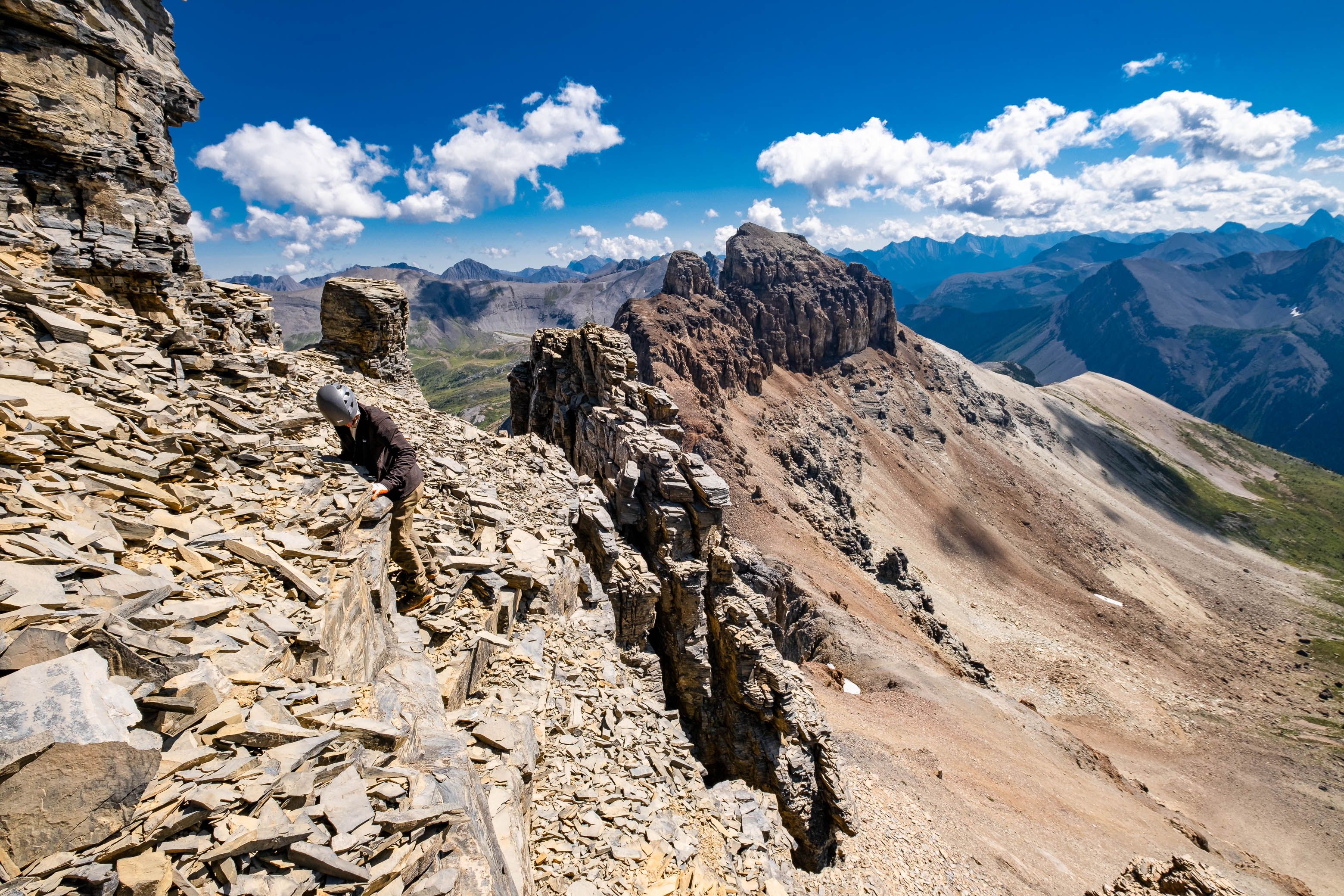
We chose the broad gully angling up to our right, and soon topped out at a "ridge" between our gully and another gully leading down the other side. Immediately in front of us lay yet another chimney, this one breaking through a second major cliff band. I started up first, with my dad waiting safely out of the "fire-zone" (lots of rockfall hazard on this mountain!), and carefully made my way up the crumbling ledges and unreliable holds. What's nice about chimneys, is that they give you an extra sense of security in their narrow confines, making the exposure less noticeable, but as we continued out of the chimney and up the rotten face above, it quickly became obvious that a slip here was completely out of the question!

With nearly every hold pulling out when tested and loose rock covering literally everything, we had to put our full concentration into this slope and step so incredibly carefully. While the moves themselves weren't anything crazy I have absolutely no trouble giving this mountain a Class 4 rating due to the loosness and exposure on this final slope.
It's impossible to describe the feeling I felt as the slope eased off and I could see nothing higher than a small pile of rocks just a few easy steps away. With the popularity of scrambling increasing, there aren't many peaks that don't have multiple detailed route descriptions to be found online or in books anymore and finding your way to the top of a rarely ascended peak with absolutely no beta or route information is such a rewarding feeling that simply can't be matched.


Curious if anyone had ever taken the route we just discovered, I rummaged through the small summit cairn, eagerly looking for a register. After being unsuccessful in finding one, I got ready to place one of my own, only to realize it was still sitting deep in my backpack far below 😔. Having brought a register along specifically for this day, I was honestly pretty bummed that I'd forgotten it, but there wasn't much I could do about it now, so I simply added a rock to the cairn and lifted my spirits by switching my attention to the absolutely stunning 360 degree views from our little perch atop Naiset Peak.
Assiniboine's east face was completely free of clouds on this bluebird day, still towering a monstrous 800 m above, and the deep blue shades of Lake Magog, Sunburst Lake, Cerulean Lake and Gog Lake were all visible amongst a lush green valley, contrasting the harsh, rugged line of peaks on which we stood.
While I probably could've spent a good hour relaxing up there on this beautiful, calm summer day, I could tell my dad was getting antsy, nervous about the descent, and I myself knew that we really didn't have time to waste, having spent much more time climbing this peak than I had anticipated and still having an over 25 km trek between us and our car before a long drive back to Edmonton that same evening!


We carefully retraced our steps back down from the summit block, treading as lightly on the loose rock as we possibly could. While this isn't often the case, I actually found the downclimb easier than the upclimb on the summit block. Now don't get me wrong, the downclimb is by no means technically easier, but with now knowing exactly how to solve the "puzzle", I felt a lot less mental strain than I did while navigating completely unkown terrain on ascent. After a slow and methodical descent, we soon found ourselves squeezing back through the lower chimney and were strapping our heavy packs back on before continuing down much easier terrain back to the col.

The servere instability of the rock just below the col led, once again, to some tense moments, and it wasn't until the slope finally began to ease off at the base of the upper bowl that we could finally relax knowing the worst was now behind us for good.

The remainder of the descent went without difficulties, with the only difference from our ascent being that we took a more direct line down the lower basin towards the Wonder Pass Trail. After leaving the massive rubble basin behind, we followed meadowy slopes around the base of The Towers and intersected said trail just below the pass. Now all that was left was a looooong mindless trek back to Mount Shark.


By the time we reached the eastern end of Marvel Lake, the exhaustion was really starting to kick in. My shoulders were absolutely relieved as I dropped my pack at my side and stretched out on the grassy shores. As we gazed across the beautiful lake, accompanied by a slight breeze and the distinct scent of wildfire smoke starting to drift in, we reflected once again on how incredibly lucky we'd gotten on this trip. After coming scarily close to canceling the whole thing due to the smoke forcast, our entire trip had been completely smoke-free, only starting to blow in on our hike out, on the very last day. Now if that isn't a fairytale kinda story then I don't know what is!
You know we were a little bit out of it when after our short break at the lake we started right back up the trail we'd just come down (rather than down the trail that leads directly to Bryant Creek, past the BR13 Campground), and didn't notice until about 200 m in 🤦♂️. The Bryant Creek Trail was truly starting to feel monotonous (once we were actually on it 😂) for the final few kilometers leading up to our bikes, and we greatly appreciated the change of pace once we reached them, easily cruising the final 6 km back to the parking lot.


What a trip!! We finished off having clocked 108 km, 6000 m of elevation gain, and 14 peaks bagged in four days, easily making this my biggest consecutive four-days in the mountains to date! I can't stress enough how thankful I am that the weather held up perfectly for us, allowing us to bring my crazy peakbagging plan to life, rewarded with absolutely stunning views throughout!
As for the subject of this report, Naiset Peak, can I say I'd recommend it? To be completely honest, no, not really. You can get a nearly identical view from the top of The Towers and have a much easier (AND SAFER!!) time reaching it. But, of course, if you're a diehard peakbagger like myself and you've already done The Towers, Nasiet Peak is one cool looking pile of rocks (very loose ones at that) that you might find yourself wanting to stand atop. Just make sure you're comfortable with steep, exposed, and horribly loose terrain (this has got to be a record for how many times I've said "loose" in one report 😂) , bring a helmet, and personally, I wouldn't even think about doing this with a party bigger than two.
What I can say, is that a trip to the Assiniboine area (no matter how you spend your time there), is something I can very, very easily recommend! There aren't landmarks with the names "Marvel" and "Wonder" for no reason, and I guarantee you'll be blown away by the views you get when you step foot into this beautiful park. This may have been just my first trip to this magical area, but I promise you it won't be my last! There are so many more mountains, lakes, and valleys to explore, and maybe, just maybe, someday I'll even be back for the Mighty "A" itself...
Photo Gallery


Disclaimer