Date: July 28, 2023
Location/Route Map: Assiniboine Provincal Park
Elevation: 2755, 2495 m
Elevation Gain: 660 m
Distance: 10 km (from Lake Magog Campground)
Rating: Class 2/3 - Easy/Moderate
Notes: Nub Peak is largely an ON-trail hike with only minor bits of easy scrambling. Combining it with an ascent of Chucks Ridge requires moderate scrambling with exposure via Nub's SW connecting ridge.
GPS Track: Download
A significant amount of rain fell during our second night at Lake Magog, but when we awoke in the morning the world around us was quiet and still. I unzipped our soggy tent door, anticipating another perfect morning, but what I saw instead was nothing...literally. We were completely "clouded-in" and a couple hundred meters of eerie forest was all I could see before everything faded away into a dense fog. Groggy and unmotivated by the dreary weather, I dropped back onto my sleeping pad and closed my eyes. As I lay there, however, I started thinking...What if we were just trapped in a low-lying fog, hovering over the lake, and if I got my lazy butt up and hurried to the top of a mountain I might be able to catch some surreal views of Assiniboine rising high above the clouds! Just like that my mood did a complete 180 and I was wide awake, rushing to get out of camp and above the fog before it dissipated! Nub Peak is likely the most frequently ascended peak in all of Assiniboine Provincal Park. If you go look up pictures of Assiniboine I'd bet money that a good chunk of them will be from one of the viewpoints along Nub Peak's SE ascent ridge. People from around the world come to photograph from this famous location, and for good reason! Overlooking both Sunburst and Cerulean Lakes, Sunburst Peak's sheer north face towers above, only to be overshadowed by the pyramidal form of the mighty Assiniboine itself - This scene truly is something special. Thanks to this peaks popularity, a well-defined trail leads easily from the campground right to the summit, and made for the perfect morning objective in our mission to escape the clouds!


It was here, at Cerulean Lake, that I was genuinely happy I'd left the cozy warmth of my sleeping bag and headed out into the cold, soggy woods. The clouds started to lift from the lakes surface as we approached, slowly revealing Sunburst Peak's stunning form, breaking through the clouds and rising high into the morning sun! This sight was pure magic! While the rest of the campground was still cozy in their tents we had the lake entirely to ourselves admiring one of my favorite views of the entire trip in complete peace and solitude.


After spending almost 20 minutes taking waaay to many pictures as the scene continued to evolve, I eventually pried myself away and we continued up the trail for a short distance, soon arriving at the junction (signed) switch-backing back up to Nub's SE ridge. As we passed the treeline we were once again awestruck by the views back across the valley, and stopped for a few minutes to admire the scene before leaving it all behind as we climbed into the clouds.

Even though there was nothing to see, we made a brief detour to The Niblet (the first viewpoint along Nub's SE ridge), just for the heck of it, before continuing up the ridge. The clouds were constantly moving, swirling around us and allowing us brief glimpses of Sunburst Peak and Assiniboine's north glacier from time to time, but by the time we reached the top of The Nublet (the second viewpoint) we were in deep and "outside world" had completely vanished from sight.


Even in the whiteout, routefinding was never an issue and we easily followed the few meters of trail that we could see in front of us up the final 200 vertical meters to the summit. It's wierd how fast time seems to go by when you have no reference of distance. I was reminded of our whiteout ascent of Mount Norquay a couple years ago as we climbed, and just like back then, the summit snuck up on us a whole lot sooner than I was expecting!


The summit was impossible to miss thanks to the human-sized summit cairn (speaks to this peaks popularity!), but unfortunately this pile of rocks was the only thing interesting enough to take pictures of, and after waiting around for a few minutes, hoping the clouds might miraculously part, we accepted our fate and were soon starting back down. Just as we took the first few steps down the ridge, however, I noticed a window opening up to the west and got my camera out just in time to capture some beautiful light of Nestor Peak's lower slopes before more clouds drifted in and the scene vanished just as quickly as it had appeared.


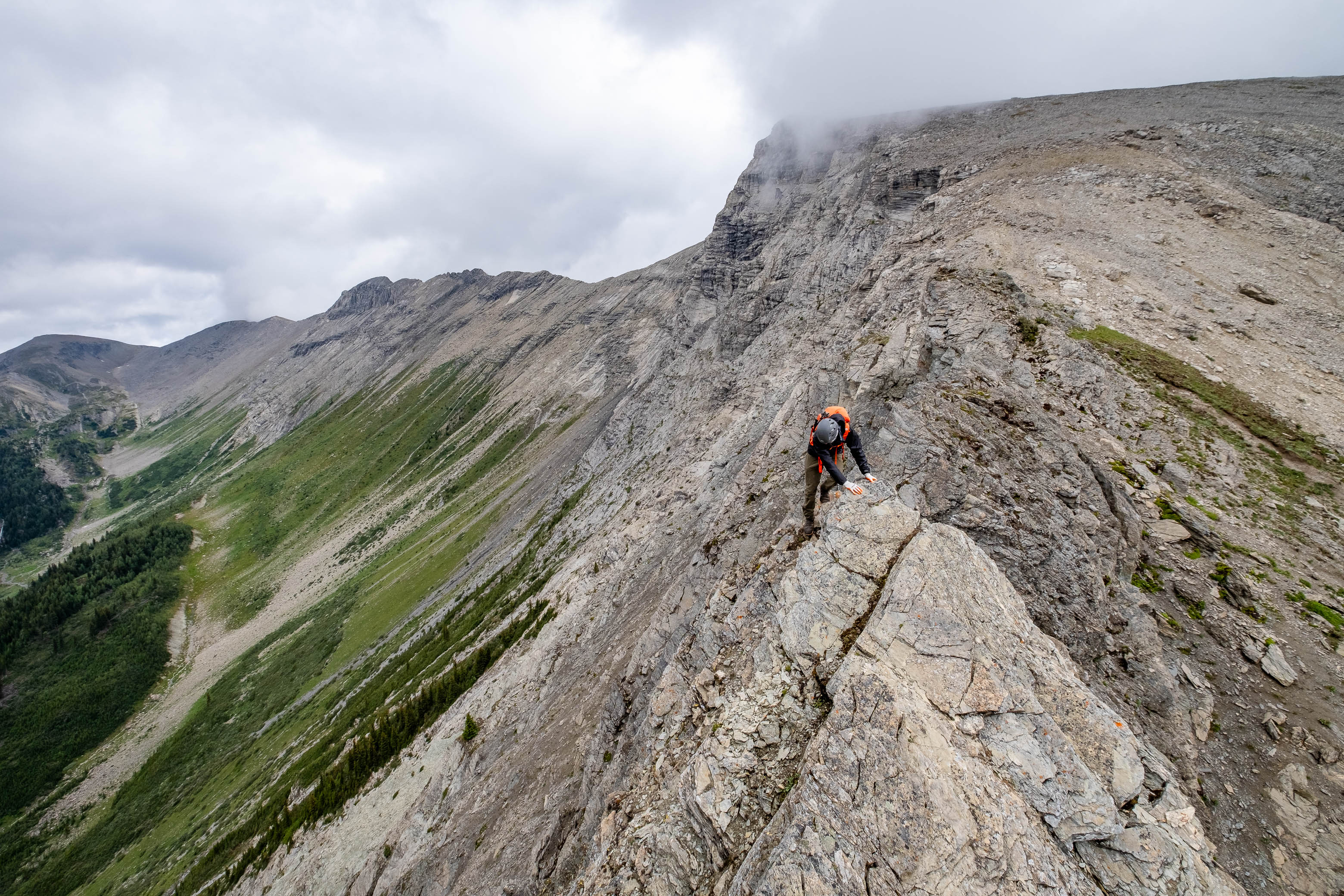
As we descended back out of the clouds, we were accompanied by stunning views once again and also got our first look at Chucks Ridge...It looked like we were in for a challenge indeed! The summit was guarded by a steep cliff band that looked like it had the power to put a quick end to our summit bid, but if you've scrambled much in the Rockies, you know that difficulties tend to look worse than they really are from afar, and we didn't waste much time before starting up the opposite side of the col to stick our noses in and see what Chucks Ridge really had in store for us.


We started up a very short slope of dirt and shale, easily taking us to a mossy ridge that we followed to the base of the summit block without difficulty. The summit block sure looked intimidating as we approached and stared us down as we carefully traversed a narrow, exposed ridge separating us from the final step guarding the summit. (Extra careful footing was required on the slabby bits thanks to the overnight rain.) When we found ourselves face to face with the final section of scrambling, however, we were surprised by how simple it now appeared and had absolutely no trouble ascending a broad "crack system", with good holds, right to the top of our second summit of the day!


The sun broke through the clouds and shone brightly on our summit perch as we enjoyed incredible views down to the lush green valleys and deep blue lakes, contrasted by the bright, cotton candy clouds still clinging to the tops of the loftier surrounding peaks. We spent some time just relaxing on the summit, soaking in the warm sun and sublime views before continuing down Chuck's west ridge.


I was surprised by the amount of routefinding and scrambling opportunities that were present on our descent route. Although the ridge starts out quite tame, it soon breaks up into a collection of massive blocks as if it was sliced into pieces with a giant knife! There were multiple instances where I thought we might get cliffed out, but we detoured to skier's left when necessary and were always able to find a sneaky little gully or ledge that would take us through the difficulties.


Eventually the big boulders broke down into smaller bits, and we easily followed the final short scree slope down to the forested ridge below. After checking out routes up both sides of this ridge, I'd have to rate both as moderate scrambling. The west side requires more routefinding, while the east side has some exposure to contend with. Personally, I found both routes to be quite enjoyable and would definitely recommend doing a loop like we did to fully experience all that this little ridge has to offer 🙂!


Speaking of fully experiencing this ridge, we still had lots of time in the day and decided to make a quick visit to the viewpoint at the far western end of the ridge before following a good trail down to Elizabeth Lake and back to the campground on route to our third and final summit of the day!

Photo Gallery


Disclaimer