Date: October 11, 2022
Location/Route Map: Kananaskis Lakes
Elevation: 2540, 2670, 2650 m
Elevation Gain: 1130 m
Distance: 9.1 km
Rating: Class 3 - Moderate
Notes: Being respectful of, and not disturbing, the grizzlies is likely the crux of this trip. Bring a helmet and a small party for the loose ascent gully and expect some exposure if completing the full traverse.
GPS Track: Download
There's lots of controversy when it comes to Mount Indefatigable. You can find all kinds of differing opinions online, ranging from those strongly advocating for the trail to be officially closed, to those who say it's really no big deal, to those (like myself) who believe that you should read what others have to say, and make your own informed decision whether you venture up this mountain or not. Why so controversial you ask? The upper slopes of Mount Indefatigable are a prime grizzly habitat, often used to raise their young. Human traffic not only puts the human at risk, but can also disrupt the grizzlies. The approach trail has therefore been decommissioned, but not officially closed. With that being said, I've been wanting to climb this mountain for quite a while, and there are a couple of reasons for that. 1.) Mount Indefatigable is strategically placed right between Upper and Lower Kananaskis Lakes, promising an extremely unique view down to both. And 2.) A goal/dream of mine is to summit all of Kane's scrambles (plus many more ;)), and Indefatigable just happens to be on that list ¯\_(ツ)_/¯. Even so, I greatly respect and value our nature and wildlife, and therefore chose this scramble in mid-October, when the bears are no longer raising their newborns, and the meadows are no longer rich in bear food. In planning a day trip with some friends, Indefatigable came to mind, being relatively short, offering some fun ridge scrambling, and granting stunning views for the effort. So when Braydan, Taz and I met at the MEC parking lot at 5am on a crisp Tuesday in October, that's exactly the destination Taz set on his "big-screen TV" in the Rav...which for some reason wanted to tell us to turn onto the gravel Spray Lakes Road instead of continuing to Kananaskis Lakes 😂. Massive thank you to Taz for driving!!

Mount Indefatigable North to South Traverse Route Map (see link in desciption - or click here - for interactive version).

Mount Indefatigable, as seen from the Interlakes parking lot. The North/True Summit is hidden from this angle.

The wind was absolutely blasting across Upper Kananaskis Lake as we walked the short distance along the lakeshore trail, and it was a relief to enter the sheltered forest at the (impossible to miss), decommissioned trail sign.

It doesn't take long to reach some stunning views on this one! Although decommissioned, the trail was easy to follow, and we were soon up on Indefatigable's lower, south ridge, looking out across the beautiful Upper Kananaskis Lake.

Starting up the ridge.

Lower Kananaskis Lake joins the party, stretching out directly below us to the east!

We took a break at a grassy viewpoint, soaking in the warm morning sun and the already incredible scenery!

Golden grass.

Eventually, the ridge came to an end, and we re-entered the trees. We ignored the first trail branching off to the left (direct route to the south peak), and instead continued straight, through beautiful larch forest, soon emerging at the open cirque below Indefatigable's impressive east face. A pretty tarn fills the dried up basin for most of the summer, but was unfortunately dried up at this point in the season :(.

Looking back, as Braydan starts up the open, grassy slopes leading up to the East Peak. Indefatigable's South Summit dominates the backdrop.

A narrow trail basically leads all the way to the summit.

Mount Indefatigable's North/True Summit looks intimidating from this angle!

Braydan and Taz grind their way up the summit ridge. They collectively agreed that this section (from the dried up tarn to East Summit) was the hardest part of the climb, trumping the actual scrambling that was still to come! 😂

The long, narrow form of Lower Kananaskis Lake stretches out below, with the jagged Opal Range rising on the opposite side of the wide, flat valley.

A close up look of Mounts Invincible and Warspite, with French and Prairie Lookout visible distant-right. Apparently a traverse exists between the first two (difficult scramble) which would be fun to try!

The route up to the true summit looks pretty daunting from here...

Putnik, Unnamed, Invincible, Warspite, French, Prairie Lookout, and Murray, from left to right.

One down, two to go!

I love the vibrant colours that fall brings.

Starting up to the North Summit from the col.

Time for some scrambling!

Our approximate route up to the summit. Note the important traverse, about halfway up, that brings you to the final ascent gully.

Super neat angle of Mount Invincible!

Braydan and Taz crushing it on their first ever scramble!

Another look ahead, just before making a short traverse to get into the gully on the left.

Hoka hikers definitely wouldn't be my first choice for a scrambling boot...but he's making them work! 😆

The final gully, granting access to the summit ridge.

I'd read a couple reports of this section being super loose, with significant rockfall hazard, but I personally didn't find that to be the case. Sure, if you knock the wrong rock down it'll cause some damage, but I honestly found the short scramble, from the col to the summit, to be quite enjoyable ¯\_(ツ)_/¯.

Awesome birds-eye view of the larch filled basin, now almost 400 vertical meters below.

Mount King George towers to 3411m to the west.

Gypsum Ridge (treed hump, bottom left) along with the Opal Range (comprised of: Denny, Evan-Thomas, Packenham, Hood, Brock, Blane, Burney, Jerram, Schlee, and Elpoca) and Mount Rae rise beyond the now insignificant-looking East Peak.

Pumpkin-head poses above the pumpkin himself 😂.

Unique view across the valley to the west, with Foch, Sarrail, and Joffre rising on the left, Lyautey in the middle, and King George (distant) along with Putnik on the right.

Unique view of the larger mountains forming a circle around (and almost enclosing) little Mount Nomad in the center.

Mount Sir Douglas, rises beyond Hermione Peak, with Warspite and Invincible just to the right, and the Murray/Cegnfs duo even more right ;).

The connecting ridge to the South Peak looks like it could be fun!

Looking north towards the Kananaskis Range, framed between Invincible and Indefatigable East Peak.

A couple of small tarns are nestled directly below Indefatigable's north face.

Summit group shot!

Placed another summit register :)!

Looking back to Braydan and Taz on the summit, after taking a quick look down the connecting ridge to Invincible.
Just like when we walked along the lake this morning, the wind was absolutely howling up here, and we didn't stay too long before starting down the connecting ridge.

Imagine forgetting gloves and having to wear socks on your hands 😂. Maybe I shouldn't make fun...I was the one with a pinky finger so cold that I physically couldn't straighten it when we reached the South Peak! I had to stick my hand under my armpit for 10 minutes before it regained function. Maybe Mr. Sock Hands over here knows what he's doing! LOL

While some trails seem to be forming on the left side of the crest, we chose to stick to the solid rock directly on the ridge, tackling any downclimbs head-on (moderate scrambling).

Indefatigable's South Peak looks so isolated, and juts out like a shark fin from this angle.

Another downclimb.

We soon reached the low point in the ridge, and it was all up to the South Peak!

Scrambling up what some consider to be the crux of the traverse...The holds are all really solid, so this section didn't cause us any trouble. Photo credit: Mr. Taz

Looking back, from the top of the "crux".

Braydan scrambles up. Note the sheer drop to the right!

Taz takes on the one slightly awkward step on the crux.

Mount Rae is visible in the distance, beyond glowing larches, and a deep blue, Lower Kananaskis Lake.

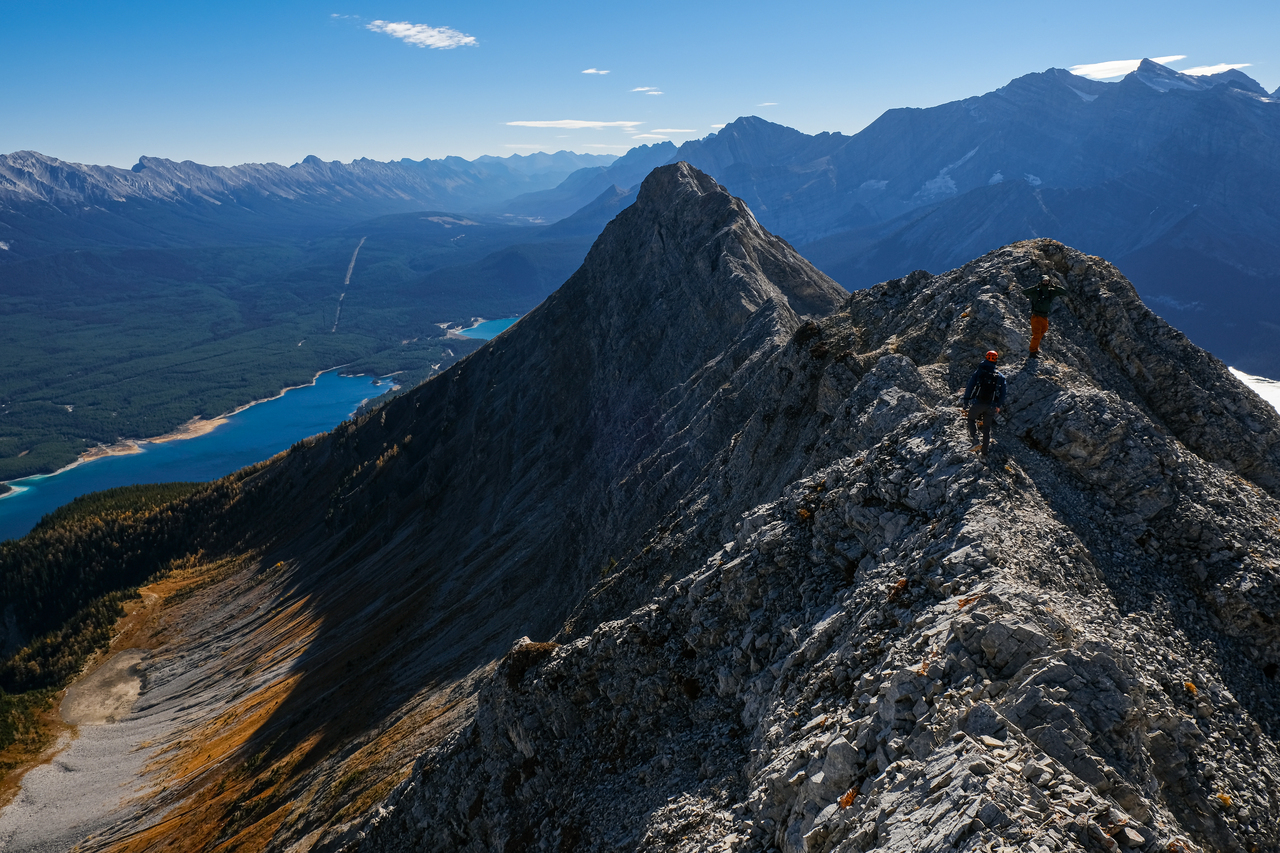
Braydan traverses a narrower section, just before the summit.

Absolutely beautiful valley to the northwest.

Looking back up the connecting ridge to the north summit.

11,000er #1: The distant Mount Sir Douglas makes everything around it look small.

11,000er #2: Mount King George, the highest summit of the Royal Group, is visible far beyond the vibrant valley below.

11,000er #3: Mount Joffre, the highest peak in Kananaskis, overlooks the nearly evaporated Hidden Lake.

Beautiful lighting on the impressive connecting ridge to Mount Invincible.

Mount Inflexible stands out, rising at the end of Mount Kent and Mount Lawson's paralleling ridges, with The Wedge's distinct form visible down the valley to the right.

Lower Kananaskis Lake's far shore has got some character!

The sun highlights the first two peaks of our traverse.

We quickly continued down the ridge a short ways, hoping to take shelter from the biting wind at the repeater tower!

A stunning view of Upper Kananaskis Lake was revealed upon reaching the tower!

The view of Lower Kananaskis Lake ain't too shabby either ;)!

Foch, Sarrail, Joffre, Mangin, Cordonnier, and Warrior impress across the upper lake.

Mount Fox rises across the lake, down Indefatigable's south ridge.

The incredible northeast faces of Mounts Foch and Sarrail tower over Rawson Lake Ridge, sitting modestly below.

Rae and Storm rise beyond the long ridge consisting of Mounts Pocaterra, Tyrwhitt, and Storelk (distant).

Pretty afternoon light on the Opal Range. From left to right, we have: Denny, Potts, Evan-Thomas, Packenham, Hood, Brock, Blane and The Blade, Burney, and Jerram, overshadowing the smaller forefront peaks of Grizzly Peak, Packenham Jr., King Creek Ridge, and Mount Wintour.

Foch, Sarrail, Joffre, Mangin, Cordonnier.

A shadowy form of Evan-Thomas East, looms behind Packenham, Hood, and Brock.

Looks like the wind is still raging down at the lake as well...

...But we've got cover! The repeater tower came through for us, and gave Taz just enough shelter to keep the pocket rocket going to cook some "crunchy" summit borscht! 😂 Photo credit: Braydan

I can't believe how such a narrow strip of land can separate these two masses of water!

The highest point of the Opal Range, Mount Evan-Thomas, rises center.

Why use trekking poles for hiking when you can have a sword fight with them?

Looking back up to the repeater tower, as we start down the south ridge to complete the loop.

Barely 100m down the ridge, we turned left, and descended a slight ridge, easily leading down to the east.

Hiking down the "ridge". After a short section of scrambling to get down from the south ridge, an obvious trail paves the rest of the route down.

You'll quickly discover if you went too far south before descending, because this is the only tame route down, and the rest of the ridge cliffs off pretty fast (look on the right side of the frame)!

Looking up to Indefatigable North and East, now rising above us once again.

Back in the forest. This narrow trail would return us back to the lower ridge without difficulty.

8km stretch of water!

Little Mount Roberta (almost always overshadowed), finally has its time to shine! The mighty Mount Rae looms in the shadows above.

Back on familiar ground. Now just a hike back down the decommissioned trail to the parking lot.

The pumpkin's got hops!

That's one way to wash your hair...

Wow, look at that exquisite form. Will he make it though?

Why climb the mountain when you get a view like this from the parking lot?...Because it's fun :).
It was great to finally bag this one! The views did not disappoint, and we didn't even see a single bear! It was incredible to experience the Kananaskis Lakes area at this time of year, free of the crowds from summer with all the campgrounds now being closed. It honestly felt like we were the only people in Kananaskis (well, aside from the one group we saw walking along the lake at the end of the day), and that was pretty cool :)! Overall it was an amazing day in the mountains with friends, and I can't wait until our next trip!
Disclaimer